|
E. Linacre and B. Geerts |
4/'99 |
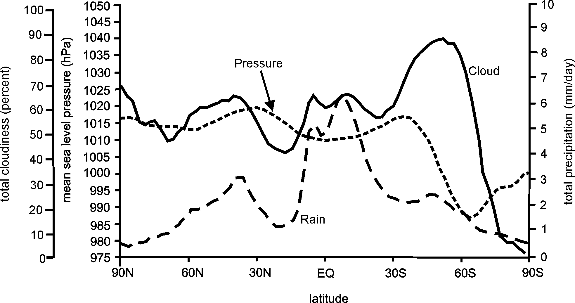
Skies are notably clear over Antarctica and at about 20° N, and to a lesser extent about 30° S (Fig 1). On the other hand, there is considerable cloud at about 60° S, the equator and 60° N, especially over the oceans. These accord with the 3-cell Palmen-Newton model of the general circulation of the atmosphere (Section 12.6), i.e. ascent at the equator and near mid-latitude fronts, notably at 50-60 °, and subsidence at the latitudes of high pressures, shown also in Fig 1.
The zonal-mean variation of rainfall correlates with that of cloudiness, but near the ITCZ the rain is more convective, allowing for plenty of sunshine, whereas frontal rain is generally stratiform and falls from extensive cloud shields. Also, at lower temperatures the saturation vapour pressure is lower, hence there is less condensation in the updrafts, and less precipitation.
Fig 1. The observed variation with latitude of sea-level pressure during December-February in 1979-88 (1), cloudiness around the world during 1983-90 (2) and precipitation (3).
Evaporation is affected by several factors, including the cloudiness (Fig 1), surface air temperature (Fig 2), wind speed (Fig 4), and relative humidity. The result is that evaporation from the oceans is as shown in Table 1, with a maxima at about 25° N and at 10° S, where the air is warm and the (Trade) wind strong. Evaporation is slightly depressed near the ITCZ because of higher relative humidity and weaker winds.
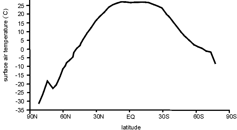
Fig 2. Zonal mean surface air temperatures at different latitudes (4).
Table 1. Variation of zonal mean evaporation rates Eo (mm/day) from the oceans, with latitude L (degrees). Negative values imply net condensation.(5)
|
L (° ) |
60 N |
50 N |
40 N |
30 N |
20 N |
10 N |
0 |
10 S |
20 S |
30 S |
40 S |
50 S |
60 S |
|
Eo |
-0.4 |
+0.1 |
2.9 |
4.3 |
4.4 |
2.5 |
3.9 |
5.5 |
4.7 |
3.2 |
2.2 |
+1.2 |
-0.8 |
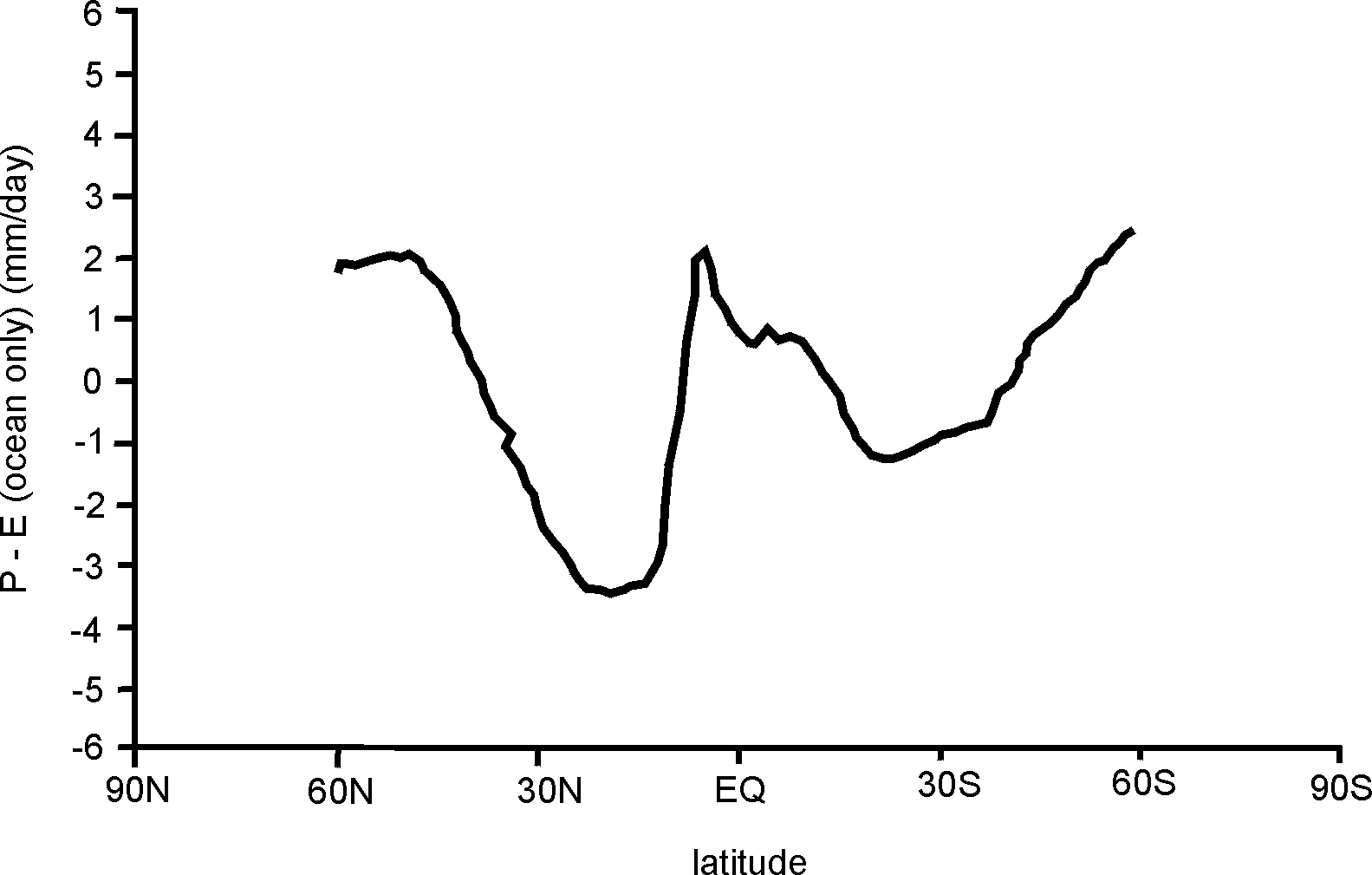
Fig 3. The difference between precipitation to the oceans and evaporation there (P-E), at various latitudes (5).
In terms of the water balance, there is a net loss of water from the oceans is most at about 20° N, and also at about 20° S (Fig 3). The ocean salinity is highest here (Fig 11.9). On the other hand, heavy rainfall yields a net gain of fresh water to the oceans at mid and high latitudes, and close to the equator. Of course rivers also contribute fresh water.
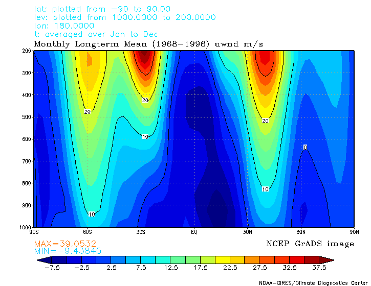
Fig 4. Mean wind (in m/s) from 1000 hPa (the surface) to 200 hPa (about 12 km) at 180°W.
Surface winds are generally westerly poleward of 30°, except near the poles (Fig 4). Midlatitude westerly winds become stronger aloft in the troposphere, on account of thermal wind balance (Fig 2). The result is a jet stream near the tropopause.
References
(1) Gates, W.L. and 15 other authors 1999. An overview of the results of the Atmospheric Model Intercomparison Project (AMIP 1). Bull. Amer. Meteor. Soc., 90, p.36.
(2) ibid, p.38.
(3) ibid, p.39, after Xie and Arkin 1997.
(4) ibid, p.36, after da Silva et al. 1994, Jones 1988, and Schubert et al. 1992.
(5) ibid, p.39, after Xie and Arkin 1997 and da Silva et al. 1994.