Global precipitation
|
B. Geerts and E. Linacre |
3/’02 |
![]()
In 1986 the Global Precipitation Climatology Project was established with as aim to obtain a better understanding of precipitation patterns as they vary regionally, seasonally, and interannually (1). The GPCP used satellite imagery (infrared and microwave) in addition to more standard raingauge data, to fill the gaps over the oceans and sparsely populated areas. The outcome is shown in Fig 1 (for a black and white contour version, click here).
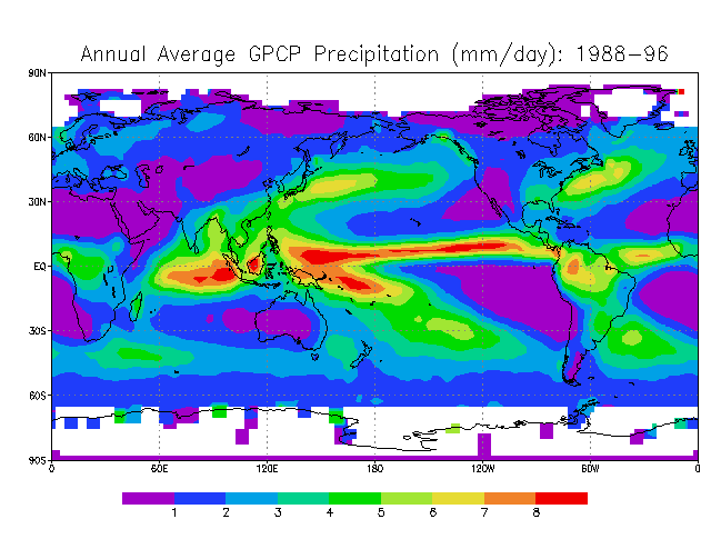
Fig 1. Annual mean rainfall between 1988 and 1996, expressed in terms of the annual mean depth of daily rainfall (millimetres per day) (Source: GPCP)
It can be seen that the heaviest rainfalls are near the equator, especially over the Pacific Ocean. A narrow band of heavy rain (about 5,000 mm/a) extends across the central/eastern Pacific around 5°N. Heavy rainfall totals also occur over the warm pool in the western Pacific (east of the Philippines - Papua New Guinea). Also visible in Fig 1 is the South Pacific Convergence Zone: at about 10°S, 170°E, the rainfall exceeds 5,000 mm annually. Over the warm pool of the western tropical Pacific, the rainfall is least on the equator, about 2,000 mm/a.
At the other extreme are the dry areas over the eastern parts of the southern Pacific and Atlantic oceans, where the sea surface is cool and atmospheric subsidence occurs over subtropical highs. The annual rainfall there is generally less than less than 250 mm/a.
Fig 1 may be compared with Fig 11.8 in the book, which shows the difference between rainfall and evaporation in the same area. The regions of negative difference have low rainfall. Of course Fig 1 does not capture the large local variations of rainfall due to orography. Mean rainfall amounts over various continents can be found here.
Seasonal variation
The average rainfall for January and July are shown below. If you have an mpeg player, then you can view the global annual march of precipitation.
|
|
|

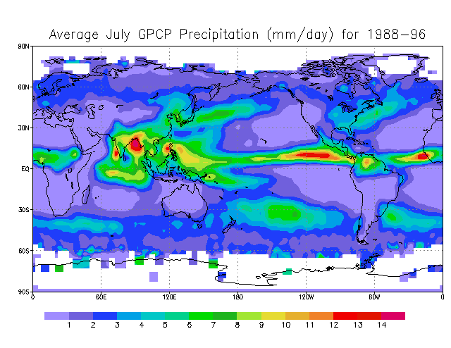
The migration of the equatorial rainy belt (the ITCZ) to the summer hemisphere can be seen clearly, especially over the continents. The South Pacific Convergence Zone is wettest in summer also. The only areas that wetter in the winter (than the summer) are the midlatitude westerly storm tracks over the oceans. Frontal disturbances are more intense and/or more frequent in winter because of the larger meridional temperature gradient.
Reference
(1) Xie, P. & P.A. Arkin 1997. Global precipitation. Bull. Amer. Meteor. Soc. 78, 2539-58.