Variation of cloudiness with latitude
|
B. Geerts and E. Linacre |
3/’02 |
Detailed satellite-based estimates of global cloudiness have been made since the mid 1980's as part of the International Satellite Cloud Climatology Project (ISCCP), and Figs 1-3 have been derived from this data set. Figs 1-2 contrasts global cloudiness in winter and summer, and Fig 3 shows the seasonal variation of cloudiness as a function of latitude in the central Pacific. At this longitude, cloudiness is suppressed at the equator (due to equatorial ocean upwelling, hence lower SSTs, hence atmospheric subsidence). The ITCZ can be seen between 5-10°N (year-round), and the SPCZ is weaker and mostly a summer phenomenon, around 15°S. The main belts of high cloudiness are associated with midlatitude cyclones (30-60°). The baroclinic storm track is found at a higher latitude and is stronger in summer, mainly in the northern hemisphere (Fig 3).
Continents tend to be less cloudy than adjacent oceans (at the same latitude), except in the equatorial belt. On average, cloudiness is highest around 60°S (about 80% of the time) but there is only 40% cloud cover at the South Pole. These figures reflect the ascent and subsidence occurring at these respective latitudes, and the large amount of ocean at around 60°S. Satellite-based cloudiness estimates over surfaces covered by snow or ice are somewhat uncertain, especially at night.
The subsidence at 20 - 30 degrees latitude in both hemispheres leads to 45 - 50% cloud cover there. This is mostly stratus clouds off the west coasts of continents, and cumulonimbus clouds over the continents in summer. At latitudes above 50°N, the annual average cloud cover is about 70%. At the North Pole there is 50% cloudiness in winter and 90% in summer.
Recent maps of the cloudiness over the globe in winter and summer (1, 2) were based on work by Berliand & Strokina (1980) and London et al.(1989), respectively. The areas of more than 80% cloud in June-August (Fig 2) lie at around 60°S over the southern ocean, around 60°N over the Pacific and north of 45°N over the Atlantic. The southern ocean band of cloudiness widens to 45 - 70°S during the warmer months of December - February, whilst the northern patches of more than 80% cloudiness are slightly smaller (Fig 1).
Less than 30% cloud at year-end occurs over much of Australia, part of China, north and west Africa, Arabia and India, California and a high-latitude part of western South America. In mid year such clear skies occur over the Mediterranean and the Near East, north Africa and South Africa, most of Australia, northeast Brazil and central South America, and coastal northwest USA.
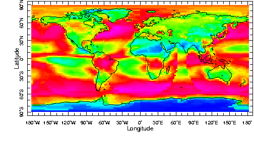
Fig 1: Average cloudiness in January. The colour code is shown below (source: ISCCP data set)
![]()
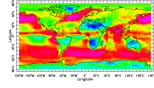
Fig 2: Average cloudiness in July (source: ISCCP data set)
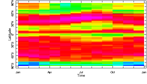
Fig 3: Average cloudiness in a meridional section through the Pacific Ocean at 164°W (source: ISCCP data set)
In summary, the Earth's albedo is highest at high latitudes (poleward of ~50°), because of the higher cloudiness, especially in areas or during seasons where/when less snow and ice cover the surface.
References
(1) Peixoto, J.P. and A.H. Oort 1992. Physics of Climate. (Amer. Inst. Physics) p.173.
(2) Barry, R. and R. Chorley 1994. Atmosphere, Weather & Climate (Routledge) p.24.