O3w :: Ozone Wind Investigation
Project Description: The Upper Green River Basin Ozone Wind Field Investigation (O3w) was a targeted monitoring effort to characterize the wintertime surface wind flow in the UGRB. During the field project, ten mesonet systems were deployed throughout the basin. Mesonet site locations were selected to form an expanded network of 20 sites that incorporated existing regulatory network and meteorological stations. Location-specific siting criteria determined whether the site observed general wind flow, or captured local terrain-induced wind flow. Several sites were also chosen because, as of 2011, no monitoring had yet been done in those locations. A map of the ten mesonet site locations along with the continuous air quality monitoring, meteorological monitoring, and UW mobile lab site locations can be found below. Wind speed, wind direction, and temperature were monitored continuously at all study sites between January 1st and March 31st, 2012.
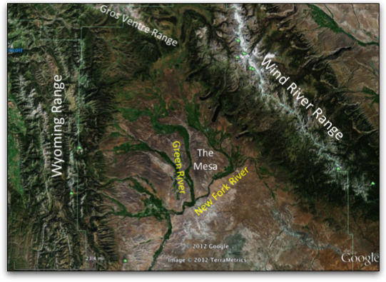
Study Area: The Upper Green River Basin (UGRB) is situated within Sublette County, Wyoming, along Wyoming’s western border with Idaho, at an altitude of 2150 m. The basin is bordered to the west by the Wyoming Range, to the north by the Gros Ventre Range, and to the east and northeast by the Wind River Range. These mountains border the basin on three sides, leaving the south side open to plains and the I-80 corridor. Prominent features within the UGRB include The Mesa, a plateau, which is elevated approximately 100 m above the average basin altitude, and is bordered to the west by the Green River and to the southeast by the New Fork River.
Hypothesis: Under stagnant conditions typical during periods of elevated ozone, local terrain-induced wind flow interacts with regional weather and creates patterns in the surface wind flow. Together, these flows determine the fate of regional elevated ozone concentrations.
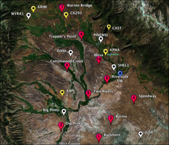
O3w site locations are numbered from 1 to 10, WDEQ continuous monitoring location are shown as white markers with circles, meteorological monitoring stations are shown as yellow markers with stars, and the UW Mobile Laboratory is shown as a blue marker with a diamond.
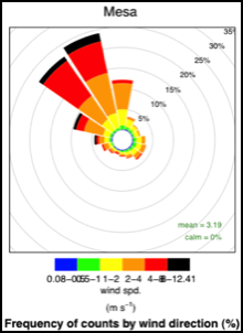
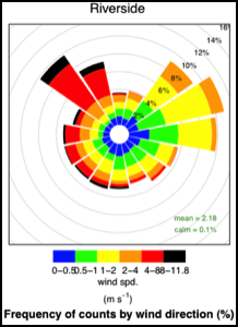
Monitoring Site Wind Roses: Below are two examples of wind roses created from the data collected at O3w monitoring site locations. The Mesa wind rose is dominated by northwesterly winds, which is the predominant wind direction in the URB, while the Riverside wind rose shows a change in wind direction with wind speed. This contrast in wind direction between high and low wind speeds could indicate the presence of local wind circulations. Wind roses for the other O3w site locations, along with a more extensive data summary can be found in the O3w Data Summary Report document.