|
E. Linacre and B. Geerts |
7/'98 |
![]()
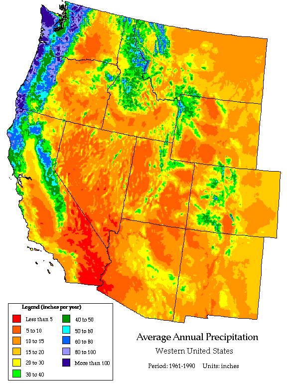
The annual mean precipitation in the contiguous United States is shown in Fig 1 below. Two patterns stand out: the gradual transitions east of the eastern flanks of the Rockies, versus the heterogeneity in the West. In the West the rainfall patterns are strongly controlled by topography and proximity to the Pacific Ocean. Places east of a N-S oriented mountain range, such as the Cascades of Washington and Oregon, are dry, drier than places at the same elevation on the west side of the same mountain range. A second pattern dividing east from west is that in the East, it tends to be wetter to the south, where warmer air holds more water vapour, which largely originates over the Gulf of Mexico. In the West, it is wetter to the north, as most frontal systems stay north, especially in summer.

Trends and cycles
Precipitation trends and cycles are usually hard to detect and insignificant compared to the year-to-year variability. However there appears to be a trend in the contiguous United States. Precipitation increased by about 10% since 1910 (1). Both the rainfall frequency and intensity have increased. There are six more days with rain each year since 1910, on average, and there are more days with heavy rainfall, e.g. over 2'' (50.8 mm/day). The percentage of total rainfall contributed by falls within the top 10 percentile has increased from 36% to 40%. The median rainfall shows no trend, on the whole.
There appear to have been cycles of about 20 years and 12 years in the annual rainfalls in five states in the Midwestern USA over the past century (2). For instance, at Columbia (Missouri) a maximum of about 1,100 mm/a around 1942 was preceded by a minimum of about 88 mm/a around 1932, and followed by one of about 820 mm/a around 1954. The various minima corresponded to times of drought in the 1910's, 1930's, 1950's and late 1970's.
These interdecadal rhythms seem limited to the Midwest and central plains, and not to be present in the eastern and northern parts of the contiguous US. The quasi-12-year cycle is not evident in most of Nebraska.
A reduction in the amplitude of the 20-year cycle since about 1965 has been accompanied by an increase of the 12-year cycle, with an increase of annual rainfall overall. It is suggested that the changes are due to alterations in sea-surface temperature and sea-level pressure in the north Atlantic, which have the same periodicities and relate to the intensity of the Bermuda high, i.e. the North Atlantic Oscillation. This anticyclone controls a low-level jet across the plains which brings moisture there.