The North Atlantic Oscillation
|
B. Geerts and E. Linacre |
3/’02 |
![]()
Definition
|
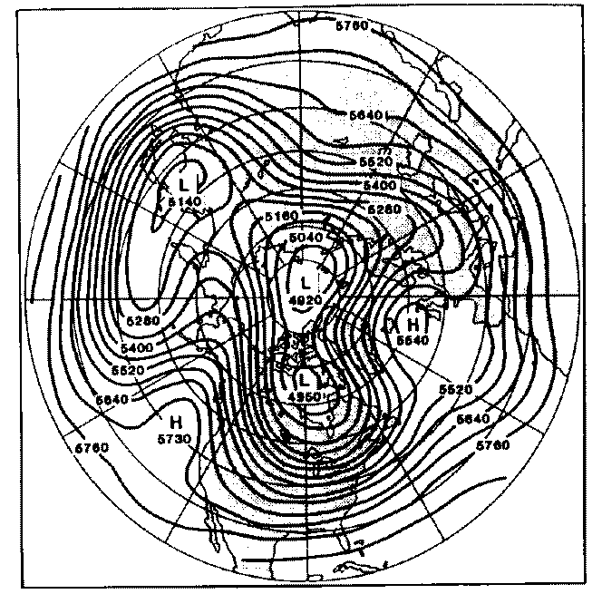
There is a variation of the westerly winds in the northern Atlantic Ocean which bears some similarity to the El Niño Southern Oscillation in the equatorial Pacific (1). This oscillation, the North Atlantic Oscillation (NAO), is measured by the difference between pressures at two places at much the same longitude but widely separate latitudes (Iceland and the Azores), whilst the SOI refers to pressures at low-latitude places of different longitude. The SOI indicates the strength of the Trade winds, which are almost always easterly, whereas the NAO Index relates to the speed of midlatitude westerly winds. Near the equator, the wind blows down the pressure gradient, because the Coriolis effect there is negligible, whereas in the midlatitude belt, the wind is approximately aligned with the isobars (Note 11.D). More correctly, the NAO Index is the normalized anomaly of the 500 hPa height difference between the Azores at 39° N and Iceland at 64° N, both around 24° W. A low NAO index implies a weak upper-level westerly winds in the North Atlantic, i.e. the zonal index, defined in Section 12.5, is low. An example of a low NAO index situation is shown in Fig 1. A lasting low-NAO index situation corresponds with a blocking event. A split in the upper level westerly flow can be clearly seen at 15° W. The event shown in Fig 1 lasted the entire month and caused record-breaking cold weather in northwestern Europe, warm conditions in Iceland, and wet weather in southern Spain and Portugal. The NAO can be estimated from historical data since the late 19th century, and from ice-core data from Greenland, providing a proxy record of the NAO since the last Ice Age (3). |
Fig 1. Mean 500 hPa height chart for the northern hemisphere for January 1963. (Source : (2)) |
Cycles
The NAO Index varies at time scales of days, weeks, months, decades, and centuries, but there are no clear cycles (4). Fluctuations of the NAO Index over days to weeks are due to atmospheric processes alone. The strength and evolution of the NAO index can be anticipated fairly well by medium-range weather prediction models out to 8-12 days. These models are not coupled to the ocean circulation. On days when the NAO Index is high, there are strong winds, bringing mild and wet conditions over western Europe. On the other hand, a low Index means prevailing meridional flow and, in western Europe, incursions of cold polar winds from the north and east in winter.
|
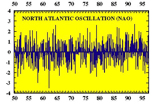
The NAO Index can also be calculated for monthly-mean data (Fig 2). These longer-term NAO index variations are intimately connected with alterations of currents and the thermohaline circulation in the northern Atlantic ocean. Air-sea interaction in the North Atlantic appears to be more complicated then in the equatorial Pacific: in the case of ENSO, no deep-ocean circulations are involved. Certainly, there is no clear connection between the NAO and the ENSO. Between 12,900 and 11,650 years BP, at the end of the last Ice Age, fossil records indicate a sudden cooling, mainly in eastern north America and in western Europe. It has been suggested that the cooling during this period, known as the Younger Dryas, was due to the shutting off of the deep-water formation between Greenland and Iceland (Fig 11.19 in the book) (5). Considerable research effort is going into the study of North Atlantic oceanography, to clarify matters. A sequence of cold winters in the 1940’s and 1960’s, and warmer conditions in the 1990’s, correspond to variations of the NAO Index. This has been seized upon by critics of the idea that fossil-fuel-burning has been chiefly responsible for warm years in the 1990’s (1). Time will tell. |
Fig 2. The monthly-mean NAO Index, from 1950 to 1997 (source: NOAA). A value of -1 means that the westerly winds at 500 hPa between Iceland and the Azores are one standard deviation weaker than the mean. |
The NAO and the Indian monsoon
The timing and intensity of the Indian summer monsoon is essential for the lifelihood of the Indian society. During the past 65 years monsoonal rainfall amounts have slightly decreased in India, except in the northwest, where there has been a slight positive trend during the 20th century. More importantly, monsoons have varied significantly in strength and duration, and correlations with the ENSO are rather weak.
108 years of data have been used (6) to show that the January NAO Index is significantly related to the monsoon rainfall over the whole of India (except in the northwest) during the following summer. The greater the winter NAO, the less the monsoonal rain. Rainfall amounts in northwestern India are related more weakly to the NAO during the preceding winter and spring (December - May). If this study is correct, then the NAO can be used as a predictor for the Indian monsoons.
References
- Morton, O. 1998. The storm in the machine. New Scientist, 157, 22-7.
- Ghil, M. and S. Childress, 1987. Topics in Geophysical Fluid Dynamics: Atmospheric Dynamics, Dynamo Theory, and Climate Dynamics. Springer-Verlag ??pp.
- Hurrell, J.W. 1995. Decadal trends in the North Atlantic Oscillation regional temperatures and precipitation. Science, 269, 676-9.
- Stephenson, D.B. 2002. Forecasting the North Atlantic Oscillation. (on the web)
- Broecker, W.S., and Denton, G.H. 1990. What drives glacial cycles?" Scientific American, 262, 49-56.
- Dugam, S.S., S.B. Kakade and R.K. Verma 1997. Interannual and long-term variability in the North Atlantic Oscillation and Indian summer monsoon rainfall. Theor. Appl. Climatol. 58, 21-9.