The climate of Sydney, Australia
|
E. Linacre and B. Geerts |
11/'98 |
Sydney is a coastal city at 34° S, so its temperatures are mild year-round (Fig 1). However Sydney's air temperature has risen faster than in the rest of Australia during the last century, largely because of urbanization - the metropolitan area now counts about 3.8 million people. The city is north of the normal path of highs across Australia in summer, and south of them in winter (when they move at about 24° S). Therefore the geostrophic winds tends to be either easterly (most commonly in January-May) or westerly (most commonly in July-November). The axis of the subtropical high is overhead in April and October, on average. In winter sea-level pressure inland is higher than in summer, leading to offshore, dry flow.
Offshore there is commonly a branch of the Pacific gyre carrying warm water southwards. This warm current is typically 100 - 600 km across, though there is occasional upwelling of cold water onto the continental shelf, which extends about 90 km offshore.
Frontal lows often affect Sydney, especially in winter, but they are usually dry. This is because the lows remain far to the south, and the passage of a cold front is associated with a shift from warm and dry northwesterly winds to colder, more humid southwesterlies, which loose much of their water vapour over Victoria and the Dividing Range west of Sydney. There is a 2 - 3 K foehn effect as the west winds cross the mountains before the coast.
A local feature, mostly in summer, is the Southerly Burster (Section 13.3), which involves a cold front moving northwards fast up the coast, causing brief strong winds and a rapid temperature drop, but no rain, usually.
Rain falls on 40% of days, anytime of the year, but notably in January to June (Fig 2). Most rain comes mostly from major storms, not from prolonged drizzle, for instance. Sydney and other east coast locations receive most of their rain from easterly dips or east coast lows. These are subtropical lows (Note 13.C), bringing warm, moist air onshore. They can occur anytime of the year. The rain is mostly stratiform yet heavy, and continuous for 6-36 hours, sometimes leading to floods. Secondly, coastal showers often occur in post-frontal south-east flow, which becomes unstable over the warm ocean off Sydney. Thirdly, there are about 40 days annually with convective thunderstorms, especially in late spring and summer (Fig 3). Most storms approach from the west, and usually involve northeasterly winds at the surface.
In the absence of strong geostrophic winds, the weather is affected by sea breezes, especially in summer, with winds up to 6 m/s. The sea breezes moderate temperatures in summer. In winter, there are weak offshore winds at night, combining a land breeze with (in winter) katabatic flow from the Blue Mountains to the west of the city and the Hawkesbury Basin. Weak prevailing winds are often associated with poor air quality in Sydney.
There is occasional fog, of two kinds. Radiation fog occurs inland, chiefly in winter, due to nocturnal cooling under a clear sky of (moist) maritime brought inland by the previous day’s sea breeze. Advective fog can happen at any time of the year, drifting ashore from the interaction of warm water offshore, and cold water nearby on the shelf.
The climate during Sydney's Olympic Games in September 2000 is discussed in Note 16.I.
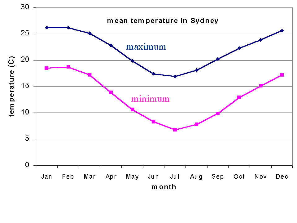
Fig 1. Mean minimum and maximum temperatures at Sydney Airport (1929-1996).
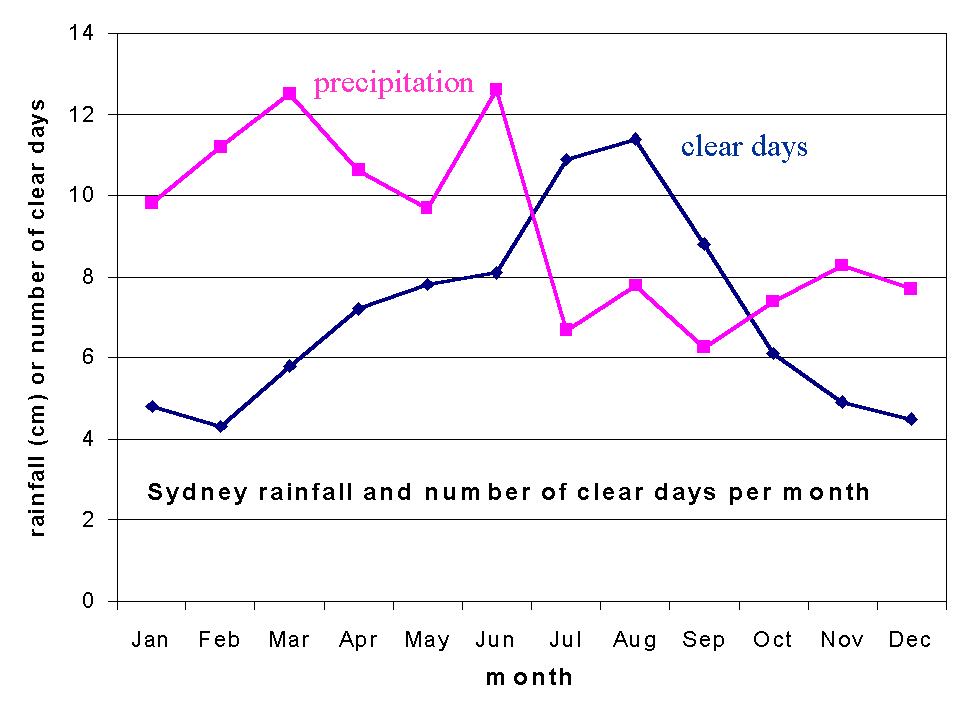
Fig 2. Mean precipitation (cm) and number of clear days per month at Sydney Airport (1929-1996).
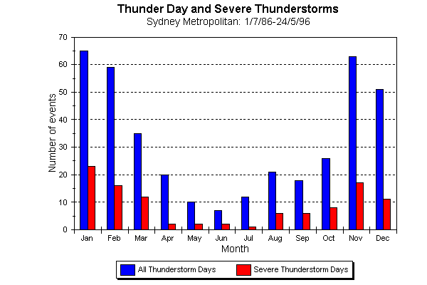
Fig 3. Number of (severe) thunderstorms per month in the Sydney Metro area over a 10 year period.