Estimating downburst-related maximum surface wind speeds by means of proximity soundings in New South Wales, Australia
July 2000
Weather and Forecasting, in press
![]()
![]()
A regional climatology of strong wind gusts associated with thunderstorms is presented, and the ability to estimate gust strength from ambient conditions is tested. Strong wind events were selected for ten stations in New South Wales, Australia, from anemograph records and coincident thunderstorm reports. Most events took place between mid-afternoon and late evening and during the warmer months of the year, which is broadly consistent with the occurrence of severe thunderstorms in general. One sounding-based index, designed to predict the strength of microbursts, proves to be of limited value in predicting the magnitude of strong convective gusts, even of short-lived gusts. A modified index that combines the microburst index with upper-level wind speed is more useful.
![]()
Extreme wind gusts associated with thunderstorms are difficult to forecast and there is a dearth of operational methods that reliably forecast the magnitude of thunderstorm wind speeds. In part, the problem stems from the range of mechanisms producing strong convective gusts. Other than tornadoes, which are not addressed in this study, these are mainly the difluence of downbursts at the surface, but also density current propagation and vertical transfer of horizontal momentum. Almost all of the kinetic energy in a downdraft converts to horizontal kinetic energy so the maximum gust speed near the edge of the downburst, upon impact, should be about the same as the maximum downdraft, however differences are possible depending on the depth of the outflow and the downdraft diameter. Negative convective-scale accelerations are largely due to negative buoyancy, which in turn is mostly explained by evaporative cooling, melting and precipitation loading (Houze 1993, p.36). Evaporative cooling dominates especially when the layer below cloud base is deep and well-mixed (Wakimoto 1985), and the incipient downdraft is rich in liquid/frozen water (Srivastava 1995). Entrainment below the downdraft base can further accelerate the downdraft if the ambient wet-bulb temperature is lower than that of the downdraft parcel, however the entrainment rate generally decreases as the downburst approaches the ground (Wakimoto 1995). Foster (1958) used proximity soundings to estimate the effect of evaporative cooling: a downdraft was assumed to start at the 'level of free sinking', where the mean moist adiabat (average between parcel and environment at 500-700 hPa) intersected the ambient temperature. He also assumed that this downdraft remained saturated to the ground. He found a poor correlation between gust speeds estimated from soundings and those observed in 100 thunderstorm events; the estimated values generally exceeded the observed ones. After careful validation and adjustment of proximity sounding data, Pino and Moore (1989) repeated Foster's procedure, but they found an even weaker correlation for 47 storms that produced both extreme gusts and hail. Wakimoto (1985) demonstrated that Foster's method (i.e. moist adiabatic descent) tends to overestimate the strength of 'dry' microbursts, because the sinking air parcel may run out of water before reaching the ground, and he agreed that this method is also unlikely to accurately predict the strength of a 'wet microburst' (i.e. a small downburst associated with a thunderstorm) (Wakimoto 1985, p. 1141). Kessinger et al. (1988) estimated that water loading accounts for ~20% of the observed downward acceleration in downbursts associated with a Colorado thunderstorm. Srivastava (1987) showed that the melting of graupel/hail may be a significant energy source, and both observations (Wakimoto and Bringi 1988) and numerical simulations (Proctor 1989) have demonstrated that microbursts tend to start at the melting level, rather than at Foster's 'level of free sinking'.
Density current propagation and downward transfer of horizontal momentum are related to convective downdrafts, i.e. they are thunderstorm outflow phenomena. A convectively generated cold pool builds due to moist adiabatic descent and entrainment of mid-tropospheric low-qe air. It then spreads at a speed proportional to the square roots of its temperature deficit and its depth. Deep, intense cold pools may be long-lived and generate waves which may cause strong gusts (Weckwerth and Wakimoto 1992). Downdrafts do carry the ambient momentum from the incipient and entraining levels to the surface, so momentum transfer from the lower (e.g. Brandes 1997) to middle troposphere is a potentially large source of strong surface winds, yet its contribution to strong winds underneath thunderstorms is poorly understood (Johns and Doswell 1992, p.596).
Long swaths of non-rotating damaging wind can be produced through a combination of mesoscale and microscale processes in bow echoes (Johns and Hirt, 1987, Weisman 1993, Przybylinski 1995). Strong surface winds in bow echoes result from a combination of downward momentum transfer, cold-pool difluence, and a horizontal perturbation pressure gradient, creating a rear inflow jet which may descend to the surface (Weisman 1992). In most storm systems damaging winds result from outflow processes, but in case of supercell storms inflow winds may also be damagingly strong (Johns and Doswell 1992). In mesoscale convective systems/complexes, mesoscale circulations induced by horizontal surface pressure gradients may contribute to strong surface winds (Vescio and Johnson 1992, Schmidt and Cotton 1989).
Strong wind gusts associated with isolated deep convection in a weakly-sheared environment are almost always due to downbursts, especially microbursts (Fujita 1990, Atkins and Wakimoto 1991, Proctor and Bowles 1992). Based on the ideas of Proctor (1989) and Wolfson (1990), McCann (1994) developed a microburst-gust prediction index, which he named WINDEX (Wind Index). WINDEX captures the environmental conditions leading to dry or wet microbursts, but it does not estimate extreme surface winds in thunderstorms in general, nor does it gauge storm probability. WINDEX was not designed to estimate gust strength in more organized storms, where processes other than downdraft spreading may be important. For instance, downbursts may occur in close proximity to horizontal or vertical vortex circulations, and sometimes a divergent microburst wind pattern cannot be readily discriminated from sheared or rotating winds (Kessinger et al. 1988).
This paper describes the climatology of strong, convectively generated wind gusts in New South Wales (NSW), Australia. Only gusts observed in the vicinity of thunderstorms are included, but the characteristics of the parent thunderstorms (size, type, longevity ?) are unknown. The usefulness of WINDEX as an indicator of the observed gust speed will be tested in Section 3. Limitations of the index and the usefulness of incorporating upper-level wind speed into a sounding-based predictor of maximum surface winds near non-tornadic thunderstorms are explored in Section 4. The climatology of extreme gusts in NSW is presented first.
![]()
2. The data and their climatology
The data gathering objective was to select strong gusts associated with thunderstorms. First anemographs were examined and only gust events of 20.5 m s-1 (40 knots) or more were selected. This threshold is twice as high as the one that defines a microburst (Wakimoto 1985). Anemographs were mainly from Dynes anemometers that continuously record wind speed and direction and have response times of about two seconds. The gust climatology is not restricted to a certain season (as in Harnack et al. 1997), however severe thunderstorms are rare in the colder months in NSW (Griffiths et al. 1993, Geerts and Noke-Raico 1995). Gusts were attributed to deep convection if either a thunderstorm was reported at the station with the anemometer ('locally' or 'in the vicinity') within an hour of the gust event, or, in the absence of hourly reports, if the strong winds were short-lived and marked by sudden, large, but unsustained changes in wind speed and/or direction. Rather than using objective criteria, events were selected manually, sometimes with the aid of corresponding surface charts, to exclude wind maxima associated with strong frontal disturbances without deep convection, but to include gusts due to lines of thunderstorms found in pre-frontal troughs. Deep convection commonly occurs in a pre-frontal trough in Southeastern Australia (Speer and Geerts 1994, Kraus et al. 2000). During the warmer months (when most strong gust events occurred) cold fronts rarely penetrate into inland NSW, but strong winds, sometimes exceeding 21 m s-1, may affect the coastal strip in association with a 'southerly burster' (Colquhoun et al. 1985). Most events included lasted less than 20 minutes, with a maximum of 33 minutes. There was no strict duration limit of events used in the selection process, although most long-duration events were interpreted as frontal and therefore were excluded. None of the extreme wind events were associated with a reported tornado, which does not exclude the possibility that some gust events were due to rotating wind.
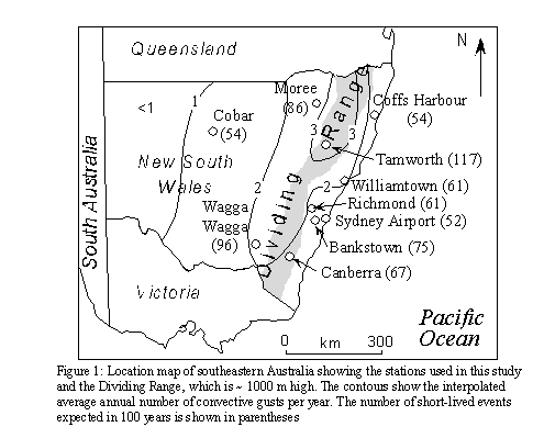
Nine anemometers in NSW and one in the Australian Capital Territory were used. Their locations are shown in Fig. 1. At least 20 years of data were used for each station with a maximum of 33 years; the periods overlapped but did not match.
Events shorter than 10 minutes and/or involving significant directional change (>90°) at the beginning of the event were classified as short-lived. A total of 476 events emerged from the selection process, of which 171 (36%) were defined as short-lived. The frequencies (average per year) are shown in Fig. 1, as contours for all events and as numbers between brackets for short-lived events. Tamworth, at an elevation of 404 m just west of the Dividing Range, ranks first for both short and longer duration events. Gust events (short-lived or not) are less common near the coast than on and just west of the Dividing Range. Extreme gusts appear least common in the desert plains in western NSW, because thunderstorms are most rare there. This is consistent with the lightning climatology (Laudet et al. 1994), which, unlike other severe weather climatologies of NSW (Griffiths et al. 1993, Geerts and Noke-Raico 1995), is independent of the very uneven population density of NSW.
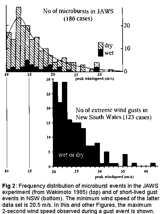
The frequency distributions of the maximum gust speeds for all events (not shown) and those of short duration (Fig. 2) show an exponential drop-off. The probability of an extreme gust halves as the wind speed increments by 3 m s-1. The strongest observed gust was 42 m s-1 and this was a short-lived event. Seven of the eight strongest gusts were short-lived. The 42 m s-1 gust occurred at Sydney Airport where a helicopter was overturned, the windows of a Boeing 747 jet broken and roofing from a terminal building stripped. Yet there was no evidence of a tornado. The exponential drop-off of short-lived gust events in NSW (Fig. 2) appears consistent with the frequency distributions of microbursts in the United States. This study focuses on extreme windbursts (at least 21 m s-1) only, i.e. the tail of the distribution. The NSW database contains more strong gust events than the short-duration (86 days) JAWS (Joint Airport Weather Studies) experiment (McCarthy et al., 1982) used for comparison in Fig. 2. The average number of days with summertime (November to January) short-lived events in NSW per anemometer was compared with microbursts greater than 21 m s-1 at a single anemometer during the JAWS and NIMROD (Northern Illinois Meteorological Research on Downbursts, Fujita 1985) experiments in the United States. The probability of at least one convective gust event of at least 40 kt in a given summer month ranges between 17-33% in the Denver (JAWS), Chicago (NIMROD), and Sydney (this study) areas. This comparison has more than an academic interest because of the short duration of the US experiments, and because the climatological gust database presented here focuses on the strongest convective gusts, which are most likely to be hazardous to aviation and on the ground.
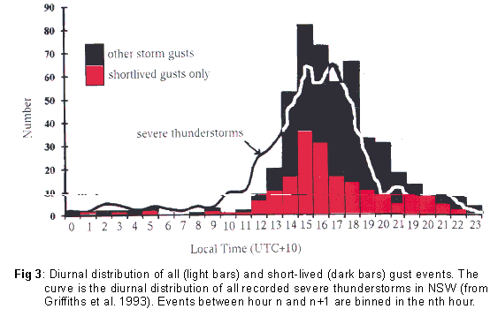
The vast majority of strong gusts has a westerly component, independent of duration. In fact 86% of the 476 gust events has a wind direction between south and northwest. The diurnal distribution of gust events, shown in Fig. 3, is similar to that of severe thunderstorms in NSW. The definition of a severe thunderstorm is somewhat different in Australia than in the USA: storms are considered severe in Australia if they produce at least one of: wind gust over 25 m s-1, large hail (at least 2 cm diameter), a tornado, or a flash flood (Bureau of Meteorology 1989). The distribution of short-lived events is more peaked than the severe thunderstorm frequency with a greater proportion of events from 3 to 5 pm local time (Fig. 3). The local time is Australian Eastern Standard Time (EST), UTC+10, even in summer. A greater proportion of short-lived events occur between noon and 5 pm (62%) compared with all events (50%), suggesting a greater dependence of the short duration events on the higher surface temperatures, and their more likely association with airmass thunderstorms, which too display a more peaked diurnal variation (Easterling and Robinson 1985).
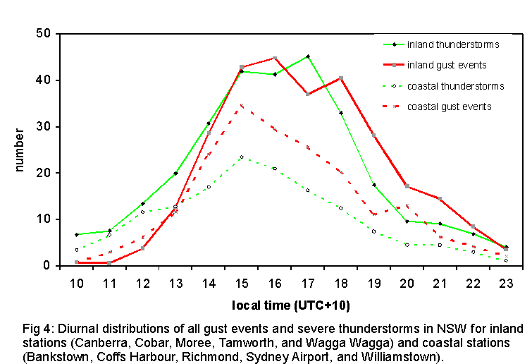
The severe thunderstorm and storm gust distributions peak at the same time, but the former is slightly skewed towards noon, while the latter is skewed towards the evening. The probability that a strong gust is long-lived is 32% higher between 6 pm-midnight than before 6 pm. These two arguments suggests that a number of gust events are associated with organized storms (lines of thunderstorms, mesoscale convective systems, possibly supercells) which have a broader diurnal distribution and may travel considerable distances. No direct information is available to classify the thunderstorms responsible for the gust events, but the distinction between short-lived airmass thunderstorms and longer-lived organized convection is apparent in the bimodal distribution of both severe thunderstorms and wind gusts at inland stations (Fig. 4): at inland stations these distributions show a second peak after 4 pm local time, while at coastal stations they do not. Deep convection at coastal stations is often triggered by sea breezes or other topographically controlled, diurnally forced boundaries, hence the distribution of both severe weather occurrences and gust events is more monodispersed near the coast, with a peak probability around 3 pm. The difference in gust frequency and inferred thunderstorm characteristics is small but apparent, and consistent with the lightning climatology (Laudet et al. 1994). Organized convection traveling across the Dividing Range in the afternoon often collapses on the lee side (Matthews and Geerts 1995), because of subsidence, and because the lee-side boundary layer has been cooled by the influx of marine air. Severe thunderstorms and strong gusts in the late afternoon and evening (between 4-9 pm) are more likely at inland stations than near the coast, presumably because deep convection is more likely to become organized and long-lived west of the coastal strip.
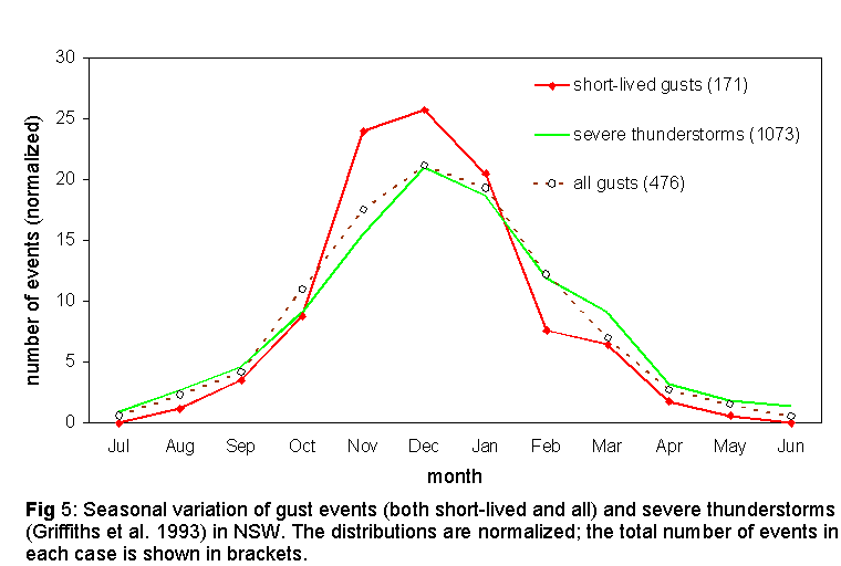
The seasonal variation of gust events is compared with that of severe thunderstorms in Fig. 5. All distributions peak in December. The short-lived gust distribution is slightly skewed towards the spring (Nov-Dec), when surface maxima are high but the humidity not as high as later in summer, while the severe thunderstorm distribution is skewed towards the late summer when flash floods are more common. The distribution of all gust events (Fig. 5) is similar to that of short-lived gusts, except that it is less peaked in the months with highest maximum temperatures and it has a slightly larger number of events in January than in November.
![]()
3. An assessment of WINDEX as a predictor of maximum gust speeds
The WINDEX (WI, in knots) was designed to estimate the maximum strength of the divergent wind near the surface adjacent to a microburst (McCann 1994):
WI = 5{HmRq (G2 - 30 + ql -2qm)}0.5 (1)
where Hm is the height (km) of the melting level above the ground; G is the lapse rate (K km-1) from the surface to the freezing level; q1 is the average mixing ratio (g kg-1) in the lowest 1 km above the surface; qm the mixing ratio (g kg-1) at the melting level; and Rq =ql /12 but is not greater than 1. Equation (1) is highly empirical. It is based on modeling evidence that microbursts start near the melting level (Proctor 1989), and that the downward kinetic energy is proportional to the depth of the descent and the square of the lapse rate excess (Srivastava 1985, Wolfson 1990). This excess is measured above the moist adiabatic lapse rate of about 5.5 K km-1 (note that 30 is the square of 5.5). The factor Rq is designed to suppress WI for dry microbursts, where q1 < 12 g kg-1, mimicking the effect of complete evaporation before reaching the ground (Wakimoto 1985). In case of wet microbursts, q1 > 12 g kg-1 generally (Atkins and Wakimoto 1991), in which case the larger value of Rq acts as an alias for the effect of water loading.
Two practical difficulties faced in calculating WI in NSW were that not all anemograph locations were radiosonde sites, and that soundings and gust events were not simultaneous. Sounding proximity and its representativeness of the pre-convective environment is a common problem in severe weather research (e.g. Brooks et al. 1994). Generally data from the nearest radiosonde, released at 9 am local time, were used. Synoptic charts were used to verify that the gust event, usually recorded 4-9 hours later, occurred in the same airmass. The lapse rate G was derived from the 9 am sounding, adjusted for the maximum surface temperature just before the event (McCann 1994). This temperature was derived either from autographic records or (half-)hourly observations. The mixing ratio qm was also derived from the sounding, and ql was estimated as the average of the mean mixing ratio in the lowest 1 km of the sounding, and the surface mixing ratio just before the gust event. Two gust events apparently occurred in environments so stable that the radicant in (1) was negative. These cases were excluded.
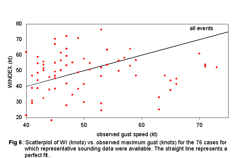
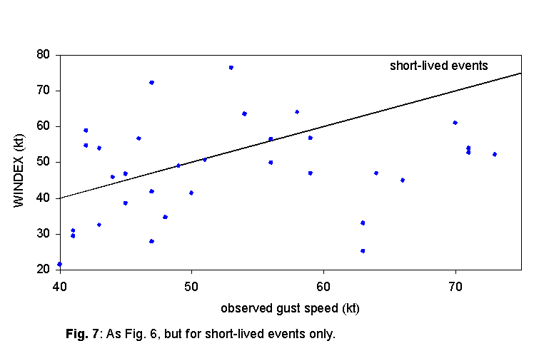
Representative sounding and surface data were available for 70 gust events (15% of the data base). For these events WI values are plotted against the observed maximum gusts in Fig. 6. For all cases where the observed gust was 60 kt or higher, WI significantly underestimated the gust strength, by an average of 22 kt. For observed gusts less than 60 kt, the average WI was close to the average observed gust, but the two variables appear unrelated. The correlation coefficient between WI and observed maximum gust is rc = 0.05. These observations suggest that WI poorly predicts the strength of strong gusts associated with thunderstorms, at least for this NSW sample. McCann (1994) favorably tested WI for both wet and dry microbursts but WI has not been evaluated for the estimation of storm-related gusts in general. A similar plot of short-lived events is shown in Fig. 7. In this case the correlation between the two variables is rc = 0.24. This small improvement stems from the fact that all true microburst events probably are concentrated in the subset of short-lived events. Still, this correlation is not significant at the 0.95 probability level.
![]()
4. Downward transfer of horizontal momentum
The WINDEX is designed to forecast gust speeds for wet or dry microbursts (McCann 1994). Thunderstorms, especially more organized storms, may have additional wind-producing mechanisms not present in microbursts, as mentioned in the Introduction. Hence it is unrealistic to expect the WINDEX to forecast strong surface winds in all (non-tornadic) convective situations. Gusts in this dataset may have been associated with any type of thunderstorms (radar data are not available), in fact both long-lived squall lines (e.g. Matthews and Geerts 1995) and supercell storms (e.g. Colquhoun 1995) have been reported in NSW.
The literature on strong, convectively-generated surface winds hardly mentions downward transfer of ambient horizontal momentum, perhaps because the mechanism is too trivial. Momentum transfer by cumulus convection is important enough to be parameterized in NWP models (e.g. Zhang and Cho 1991). A combination of momentum transfer and downburst spreading produces a highly asymmetric surface wind pattern, with extreme surface winds only on the downshear side (Eilts and Doviak 1987, Orf and Anderson 1999). Simulations of bow echoes also clearly show the importance of downward momentum transfer in the generation of strong surface winds: Weisman (1993) assumes a 25 m s-1 wind shear in the lowest 2.5 km to simulate a bow echo! The focus in bow-echo simulations is on the convectively-generated rear-inflow jet, but Weisman (1992, p.1842) states that "part of the rear-inflow strength [in a numerically simulated mesoconvective system] could be due to the downward transport of momentum from levels where the ambient winds are stronger". Synoptic conditions suitable for summertime extreme wind events in Utah include not only general conditions for thunderstorm development (i.e. the approach of an upper-level trough and deep destabilization), but also strong winds aloft (Harnack et al. 1997).
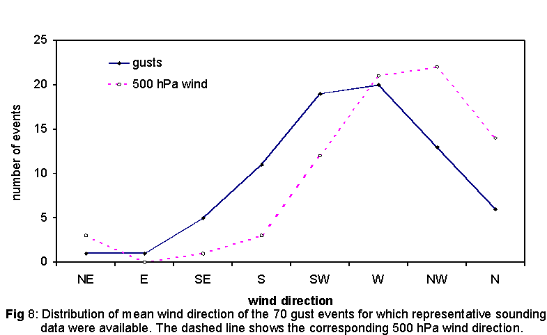
The NSW dataset itself also provides some indirect evidence that vertical momentum transfer may be important. 14 of the 70 events with good sounding data had 500 hPa winds of at least 50 kt. The wind direction of these gust events was mostly westerly, as is the case for all gust events (Section 2). Moreover the gust direction and the 500 hPa wind direction correlate well (rc = 0.96), except that upper level winds are more commonly northwesterly (Fig. 8). At the southern stations of Wagga Wagga and Canberra, 56% of the gust events less than 60 kt, underestimated by WI, occurred during June-November. June-November cases only comprise 37% of all gust events in the NSW dataset. It is possible that a number of these winter/spring events were associated with narrow cold frontal rainbands (e.g. Carbone 1982, Roux et al. 1993) deriving most of their energy from frontal dynamics, rather than from isolated convective events. In fact in all but one of the seven winter/spring cases in Canberra and Wagga Wagga with representative sounding data, the convective available potential energy (CAPE) was less than 500 J kg-1, suggesting that the convection was at least partly forced rather than driven by buoyancy.
To better estimate maximum wind gust in any kind of thunderstorm, it may be beneficial to combine downburst spreading (quantified in WI) with the vertical transfer of horizontal momentum. In what appears to be an ad-hoc afterthought, Foster (1958) added the 500-700 hPa mean wind to the gust speed estimated from the negative energy in soundings (see Section 1), but found that the correlation with observed gust speeds only marginally improved, and to our knowledge this issue has not been experimented with since. Inspired by McCann (1994) and Foster (1958), we propose a modified index, called GUSTEX (GU, in knots), which incorporates WI and the mid-tropospheric wind, as follows:
GU = a WI + 0.5 U500 (2)
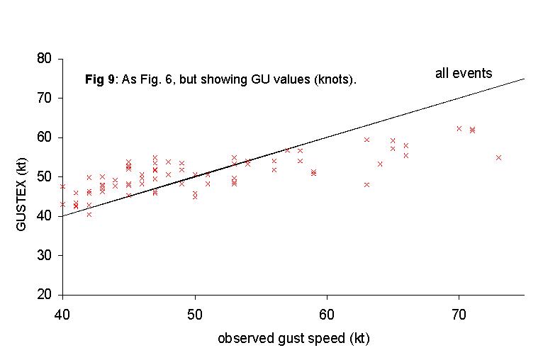
where U500 is the magnitude of the 500 hPa wind vector (kt) and a is a constant, 0<a<1. The factor of 0.5 is determined from the conservation of horizontal momentum as momentum is transferred from 500 hPa to the surface (r500/r1000 ~ 0.5, where r is air density). The factor a was chosen such that the mean GU value equals the mean observed gust speed. For the 70 gust events in NSW, a was found to be 0.60. A scatterplot of observed gust strengths vs. corresponding GU values is shown in Fig. 9. None of the GU values are below the threshold gust speed in the data set (40 kt), and some of the extremely high WINDEX cases (Fig. 7) have a lower GUSTEX. The GU values correlate much better with the observed gust strengths (rc =0.77) than the WI values, however the GUSTEX, like the WINDEX, was unable to capture the stronger observed gust events. In fact the GUSTEX still underestimates all events stronger than 55 kt. Perhaps this is not surprising since these are truly extreme gust events, in which case either the proximity radiosonde did not sample the uniquely supportive environment, or a number of convective motions conspired right over the anemometer site. On the other hand, GU values generally exceed observed gust strengths weaker than 50 kt.
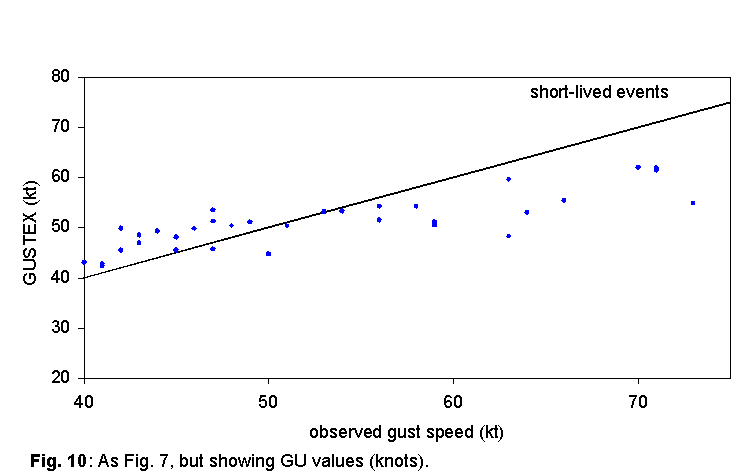
In the case of short-lived events only, GU values also correlate much better with observed gust speeds (rc =0.82) (Fig. 10). For this subset, with a = 0.6, the average GU value does not equal the average gust speed, but the difference is small (<2 kt). Again the GUSTEX underestimates the strength of gusts exceeding 55 kt, and it overestimates weaker short-lived events (<50 kt). This correlation and the one for all gust events are significant at the p=0.95 probability level. These correlations are strong enough to justify an operational trial of GUSTEX in meteorological situations for which it was designed, and for its inclusion in an operational severe weather prediction decision tree (e.g. Mills and Colquhoun 1998).
![]()
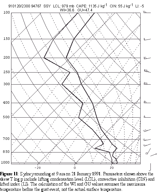
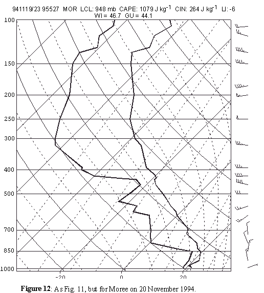
Some insight into why the WINDEX is a poor predictor of the strength of convectively generated wind gust arises from two case studies. The first, 21 January 1991, was a day on which there was major wind damage in the northern suburbs of Sydney. In this event, of all places in NSW, the WI values were lowest where the most wind damage was reported, and they were much lower than inferred and reported wind gusts. The storm that caused most of the damage occurred in a postfrontal situation, where WI values generally are low. Upper-level winds were strong (Fig. 11) especially along the central coast of NSW, therefore GU values were significantly larger than WI values there, and much of the gust momentum may have been derived from upper-level winds. In this case WI was 18 kt below the observed gust, and GU 7 kt below. Colquhoun (1995) gives evidence that the storm affecting Sydney was a high precipitation supercell. The WINDEX is not designed to assess gusts produced by these events, and the low WI values are a clear indication that the observed winds were due to organized convection. On 20 November 1994 a series of thunderstorms produced damaging winds in several parts of NSW. The 1000-500 hPa wind shear was low to moderate and the storms were prefrontal (Fig. 12). In this situation the WI values gave good guidance of the magnitude of the gusts and the highest WI values occurred near the region of damaging wind reports. More specifically, damaging winds occurred where storms moved across a strong WI gradient into an area of high WI values, as noted by McCann (1994).
The main reason why WINDEX may not a good storm gust strength predictor is that many storms producing strong gusts exist in a moderately to strongly sheared environment, in which case vertical momentum transport and organized storm circulations may be more relevant to extreme surface winds than microburst dynamics. Other factors include the possibility of elevated convection and poor sounding proximity. WINDEX tends to be too low when convection is elevated above a stable layer, e.g. above a cool marine layer in coastal NSW, as was the case in Sydney on 21 Jan 1991. Poor sounding proximity yields inaccurate estimates mainly of G and ql, given the high temporal and spatial variability of lower-tropospheric moisture (Weckwerth et al. 1996, Koch et al. 1997). Because the data set is based on extreme wind gusts at merely 10 stations, the vast majority of extreme storm winds remained undetected in the anemometer records. It is a rare coincidence that an anemometer will measure the maximum outflow wind speed. On most occasions the maximum gust will occur elsewhere even in the event of a thunderstorm over the anemometer site.
The GUSTEX is a better predictor of maximum gust strength than WINDEX for thunderstorms in NSW. One weakness in our assessment of GUSTEX is that the same dataset is used to derive GUSTEX (i.e. the parameter a in equation 2) and to test it. Consequently the dataset was divided in two subsets of 35 events each (the division was based on chronology). Each subset served as either 'source' or 'verification', and they swapped functions in a second trial. The parameter a was either 0.52 or 0.69 for the two trials, and the correlation coefficient rc was 0.38 and 0.68, respectively, i.e. worse than the 0.77 for overlapping source and verification data, but still much better than the correlation for WINDEX. Another possible weakness of GUSTEX is that a may vary regionally, therefore the usefulness of GUSTEX may depend on the quality of the local gust climatology. Also, the choice of the 500 hPa level in equation (2) is arbitrary, perhaps a density-weighted mean wind between 1-5 km above ground level would have been a better choice.
It should be noted that the actual occurrence of strong gusts under extreme observed WI or GU values is not examined in this study. Rather, the question is addressed whether observed strong gusts could have been anticipated by means of proximity sounding data. It is emphasized that WINDEX or GUSTEX should not be used as indicators of extreme storm gust probability, because such probability depends on thunderstorm probability in general, which is not gauged by these indices. An analysis of daily sounding data for January 1991, for instance, shows that extreme gusts are not more likely to occur on days with high WI values and only slightly more likely on days with high GU values.
![]()
This paper describes the climatology of convective wind gusts of 21 m s-1 or more from a small network of anemographs in New South Wales, Australia, and attempts to predict them using proximity sounding data. These are the main findings:
The probability of very strong gusts halves at wind speed increments of about 3 m s-1.
Strong convective gusts occur mainly in the mid-afternoon to evening, and mainly during the warmer months of the year.
Extreme gust frequency per anemometer in NSW is similar to frequencies during two microburst field experiments in the United States, although it is not known what fraction of the NSW events is microburst-related.
At least in NSW the WINDEX (McCann 1994) is a poor predictor of extreme gust strength near thunderstorms. It is acknowledged that WINDEX was designed to predict microburst gust strength, not gusts from any thunderstorm.
A better
correlation between observed maximum wind speed and WINDEX,
especially in the case of short-lived events, is obtained if the
latter is modified to include the effect of the vertical transfer of
ambient horizontal momentum. These correlations are strong enough
to justify an operational trial of the modified index.
A follow-up study will test GUSTEX in various regions of the USA, where radar data will be used to characterize parent thunderstorms.
Acknowledgements. Thanks go to Andrew Cearns who studied the gust climatology and computed WI values as part of his MSc thesis requirements at Macquarie University; to John Colquhoun who initiated this study, provided the thunderstorm reports, anemographs, and some sounding data, and wrote a first report; to Chris Ryan who provided the Australian severe thunderstorm data base; and to David Newhouse who hand-analyzed much of the anemograph dataset used in this study. This paper benefited from some excellent comments of a reviewer. This study was funded in part by Australian Research Council grant 20422431.
![]()
Atkins, N., and R.M. Wakimoto, 1991: Wet microburst activity over the southeastern United States: implications for forecasting. Wea. Forecasting, 6, 470-482.
Brandes, E.A., 1977: Gust front evolution and tornadogenesis as viewed by Doppler radar. J. Appl. Meteor., 16, 333-338.
Brooks, H. E., C. A. Doswell III, and J. B. Cooper, 1994: On the environments of tornadic and nontornadic mesocyclones. Wea. Forecasting, 10, 606-618.
Bureau of Meteorology, 1989: 'Plan for upgrading severe thunderstorm warning services'. 78 pp. [Available from the Bureau of Meteorology, GPO Box 1289k, Melbourne, Vic 3001, Australia]
Carbone, R.E., 1982: A severe frontal rainband. Part 1: Stormwide hydrodynamic structure. J. Atmos. Sci., 39,258-279.
Colquhoun, J.R., D.J. Shepherd, and C.E. Coulman, 1985: The southerly burster of southeastern Australia: an orographically forced cold front. Mon. Wea. Rev., 113, 2090-2107.
______, 1995: The Sydney supercell thunderstorm? Weather, 50, 15-18.
Easterling, D.R., and P.J. Robinson, 1985: The diurnal variation of thunderstorm activity in the United States. J. Clim. Appl. Meteor., 24, 1048-1058.
Eilts, M.D., and R.J. Doviak, 1987: Oklahoma downbursts and their asymmetry. J. Clim. Appl. Meteor., 26, 69-78.
Foster, D.S., 1958: Thunderstorm gusts compared with computed downdraft speeds. Mon. Wea. Rev., 86, 91-94.
Fujita, T.T., 1985: The downburst, microburst and macroburst. Satellite and Mesometeorology Research Project Research Paper 210, 122 pp.[available from the Dept. of Geophysical Sciences, University of Chicago, 5801 South Ellis Ave., Chicago, IL 60637]
______, 1990: Downbursts - meteorological features and wind-field characteristics. J. Wind Eng. Indust. Aerod., 36, 75-86.
Geerts, B., and M. Noke-Raico, 1995: Tornadoes in Australia: Do we really know ? Bull. Austr. Meteor. Ocean. Soc., 8, 46-51.
Griffiths, D.J., Colquhoun, J.R., Batt, K.L. and Casinader, T.R., 1993: Severe thunderstorms in New South Wales: Climatology and means of assessing the impact of climate change. Climatic Change, 25, 369-388.
Harnack, R.P., D.T. Jensen, J.R. Cermak, 1997: Investigation of upper-air conditions occurring with warm season severe wind events in Utah. Wea. Forecasting, 12, 282-293.
Houze, R.A., Jr., 1993: Cloud dynamics. Academic Press, 570pp.
Johns, R.H., and W.D. Hirt, 1987: Derechos: widespread convectively induced windstorms. Wea. Forecasting, 2, 32-49.
______, and C.A. Doswell III, 1992: Severe local storms forecasting. Wea. Forecasting, 4, 588-612.
Kessinger, C.J., D.B. Parsons, and J.W. Wilson, 1988: Observations of a storm containing misocyclones, downbursts, and horizontal vortex circulations. Mon. Wea. Rev., 116, 1959-1982.
Koch, S.E., A. Aksakal, and J.T. McQueen, 1997: The influence of mesoscale humidity and evapotranspiration fields on a model forecast of a cold frontal squall line. Mon. Wea. Rev., 125, 58-83.
Kraus, H., C.M. Ewenz, M. Kremer, and J.M. Hacker, 2000: The multi-scale structure of the Australian cool changes. Meteor. Atmos. Phys., 73, 157-175.
Laudet, T., P. King, and J.R. Colquhoun, 1994: A preliminary climatology of lightning in NSW. Preprints, Fourth Severe Thunderstorm Conference, Bureau of Meteorology, Australia, 38 pp. [available from the Bureau of Meteorology, G.P.O. Box 1289K, Melbourne, VIC 3001, Australia]
Matthews, C., and B. Geerts, 1995: Characteristic thunderstorm distribution in the Sydney area. Austr. Meteor. Mag., 44, 127-138.
McCann, D.W., 1994: WINDEX- A new index for forecasting microburst potential. Wea. Forecasting, 9, 532-541.
McCarthy, J., J.W. Wilson, and T.T. Fujita, 1982: The Joint Airport Weather Studies Project. Bull. Amer. Meteor. Soc., 63,15-22.
Mills, G.A., and J.R. Colquhoun, 1998: Objective prediction of severe thunderstorm environments: Preliminary results linking a decision tree with an operational regional NWP model. Wea. Forecasting, 13, 1078-1092.
Orf, L.G., and J.R. Anderson, 1999: A numerical study of traveling microbursts. Mon. Wea. Rev., 127, 1244-1258.
Pino, J.P., and J.T. Moore, 1989: An interactive method for estimating hailstone size and convectively-driven wind gusts from forecast soundings. Preprints, 12th Conf. on Weather Analysis and Forecasting, Seattle, WA, Amer. Meteor. Soc., 103-106.
Proctor, F.H., 1989: Numerical simulations of an isolated microburst: Part II: Sensitivity experiments. J. Atmos. Sci., 46, 2143-2165.
______, and R.L. Bowles, 1992: Three-dimensional simulation of the Denver 11 July 1988 microburst-producing storm. Meteor. Atmos. Phys., 49, 107-124.
Przybylinski, R.W., 1995: The bow echo: observations, numerical simulations, and severe weather detection methods. Wea. Forecasting, 10, 203-218.
Roux, F., V. Marecal, and D. Hauser, 1993: The January 12/13 1988 narrow cold-frontal rainband observed during FRONTS-87. Part 1. Kinematics and thermodynamics. J. Atmos. Sci., 50, 951-974.
Schmidt, J.M., and W.R. Cotton, 1989: A High Plains squall line associated with severe surface winds. J. Atmos. Sci., 46, 281-302.
Speer, M., and B. Geerts, 1994: A synoptic-meso-a scale climatology of flash floods in the Sydney metropolitan area. Austr. Met. Mag., 43, 87-103.
Srivastava, R.C., 1985: A simple model of evaporatively driven downdraft: application to a microburst downdraft. J. Atmos. Sci., 42, 1004-1023.
______, 1987: A model of intense downdrafts driven by the melting and evaporation of precipitation. J. Atmos. Sci., 44, 1752-1773.
Vescio, M.D., and R.H. Johnson, 1992: The surface-wind response to transient mesoscale pressure fields associated with squall lines. Mon. Wea. Rev., 120, 1837-1850.
Wakimoto, R.M., 1985: Forecasting dry microburst activity over the High Plains. Mon. Wea. Rev., 113, 1131-1143.
______, and V.N. Bringi, 1988: Dual-polarization observations of microbursts associated with intense convection: The 20 July storm during the MIST project. Mon. Wea. Rev., 116, 1521-1539.
Weckwerth, T.M., and R.M. Wakimoto, 1992: The initiation and organization of convective cells atop a cold-air outflow boundary. Mon. Wea. Rev., 120, 2169-2187.
______, J.W. Wilson, and R.M. Wakimoto, 1996: Thermodynamic variability within the convective boundary layer due to horizontal convective rolls. Mon. Wea. Rev., 124, 769-784.
Weisman, M.L., 1992: The role of convectively generated rear-inflow jets in the evolution of long-lived mesoconvective systems. J. Atmos. Sci., 49, 1826-1847.
______, 1993: The genesis of severe, long-lived bow echoes. J. Atmos. Sci., 50, 645-670.
Wolfson, M.M., 1990: Understanding and predicting microbursts. Preprints, 15th Conf. on Severe Local Storms, Kananaskis Park, AB Canada, Amer. Meteor. Soc., 340-351.
Zhang, G.J., and H.R. Cho, 1991: Parameterization of the vertical transport of momentum by cumulus clouds. Part I: Theory. J. Atmos. Sci., 48, 1483-1492