Subtropical highs vs cold highs
|
E. Linacre and B. Geerts |
11/'98 |
In the mid-latitudes surface high-pressure regions are normally transient and mobile, as they are associated with frontal disturbances. However there are two types of highs that are so geographically persistent that they are named after the region they frequent. These are the subtropical highs and the cold highs. The origin and vertical structure of these highs is quite different.
Subtropical highs
The subtropical highs at about 30 degrees latitude are dynamically consistent with upper-tropospheric convergence at those latitudes. The flow in the upper part of the Hadley cell starts as a motion polewards but becomes diverted by a zonal acceleration due to the smaller radius of curvature of rotation about the Earth’s axis at higher latitudes (the Coriolis effect) So the poleward motion becomes the upper westerlies, and the resulting convergent air must subside. The rate of subsidence within a high is of the order of centimetres a second, i.e. a few kilometres in a day.
From the perspective of hydrostatic balance (Note 1.G), the subtropical highs must be due to colder air in the upper troposphere, due to radiative cooling. Radiative cooling also occurs over the ITCZ, but there the upper troposphere is continuously warmed by convective heat exchange with the PBL. Subtropical highs can be understood as located between the trough at the equator with a warmer troposphere and the midlatitudes (45-60º) with a warmer stratosphere. The radiative cooling above subtropical highs is balanced by subsidence heating, but this balance is only attained in a slightly colder upper troposphere.
The highs tend to be more prominent in summer and more confined to the oceans, where they are located around 25 degrees latitude (Fig 1). Over adjacent land the sea level pressure is much lower in summer, due to continental heating and monsoonal latent heat release (1). Also, subsidence tends to be stronger in summer over these highs, in compensation for the broad monsoonal ascent over the continents. Therefore the Trade winds are stronger in summer. Along west coasts, the equatorward wind induces upwelling, and thus a low sea-surface temperature, which reinforces the suppression of convection.
The still surface air within subtropical highs led to becalmed sailing ships, whose crews would be obliged to eat any horses among the cargo. Hence the ‘horse latitudes’ over the oceans at about 30º.
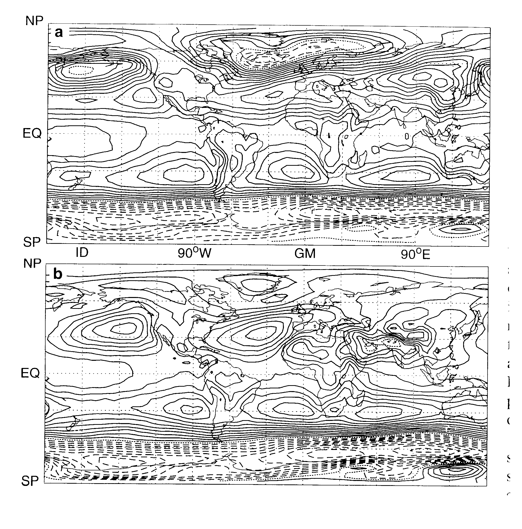
Fig 1. Average mean sea-level pressures over 5 years for a) December-February, and b) June-August. The contour levels are 2 hPa apart, with isobars below 1000 hPa shown dashed (1).
Cold highs
There is a positive feedback which tends to intensify a high-latitude continental high in winter. The subsiding air clears the sky, which then permits greater nocturnal heat loss, so that ground temperatures fall. This leads to colder air, which is more dense, increasing the surface pressure. The highest sea-level pressure ever measured was 1083.8 hPa at Agata in Siberia, and the temperature there at that time was -52ºC. This feedback does not work in subtropical deserts where the skies are clear as well, because the daytime net radiation gain there equals or exceeds the nocturnal net energy loss.
In short, wintertime high-latitude highs over land are persistent and strong, just like the summertime subtropical highs over the oceans, and the associated wind patterns in both cases. Although on occasion wintertime continental highs rush southward behind a major cold front, producing a cold-air outbreak at lower latitudes. Cold highs are shallow, because of the cold air, and a longwave trough is present in the upper troposphere. Subtropical highs are deeper.
Reference
(1) Hoskins, B. 1996. On the existence and strength of summer sub-tropical anticyclones. Bull. Amer. Meteor. Soc., 77, 1287-91.