|
E. Linacre and B. Geerts |
9/'98 |
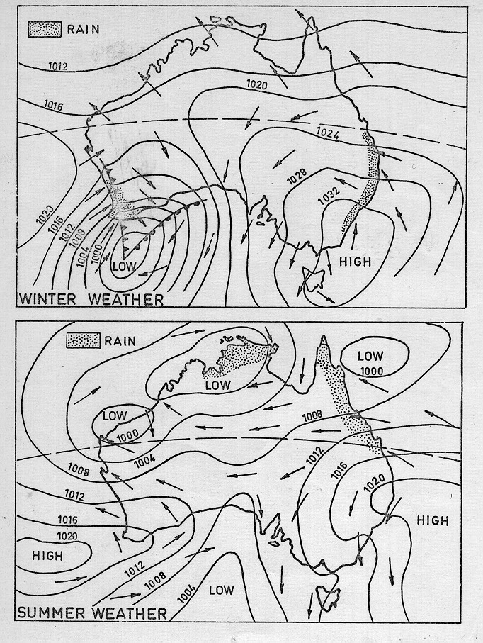
In the Australian coastal region, rainfall is to a large extent controlled by the direction of the low-level wind. Onshore flow tends to be wet, and offshore (and alongshore) flow implies dry conditions. Of course the rainfall patterns are complicated by the evolution of frontal disturbances (mainly in winter) and heat lows, with associated thunderstorms (in summer). This is illustrated in Fig 1.
A frequent wintertime pattern involves onshore (frontal) rain in the southwest, and onshore coastal rain in the east. Along the coast of New South Wales (in the southeastern corner), rain is more likely AFTER the passage of a cold front. This is contradictory with the Bergen concept of frontal disturbances, which stipulates that rain quits as soon as the cold front passes (Section 13.3). The reason for this paradox is that along the NSW coast prefrontal winds are northwesterly (offshore), and therefore usually dry and subsident, whereas postfrontal winds are often southerly, as is the case in Fig 1 (top), i.e. onshore (and up the Dividing Range). So most rain falls near the postfrontal high, rather than the frontal trough.
Dry southerly Trade winds prevent rain in the north. (Notice that northern surface winds are shown blowing almost across the isobars, because of the small Coriolis effect and light winds at low latitudes.). Rain does fall in coastal Queensland, but mainly along the coastal sections that are north-south oriented, such as near Brisbane and Cairns. Places like Townsville, with a tilted coastline, are drier, especially in winter.

Fig 1. Common weather patterns in Australia. Sea level isobars, wind directions, and fronts are shown (source: Australian Bureau of Meteorology).