|
B. Geerts and E. Linacre |
1/'99 |
Definition
Having discussed the concept of absolute vorticity (f + x) and its conservativeness (Note 12.K), we are ready to introduce another variable, potential vorticity. Potential vorticity (PV) is the atmosphere's best equivalent to a dye in water, and therefore can be used to analyse and track shortwaves aloft (and the frontal disturbances associated with it). It can also be used to explain how a range of mountains like the Andes makes the upper westerly winds swerve towards the equator and back. PV is symbolised by h and is defined thus -
h = (f + x) / Dq
where Dq is the depth of the layer we are considering, reckoned as being bounded top and bottom by two ‘isentropic levels’. Note that the units of units of PV are not the same as those of other vorticity variables. Mathematically more correctly, the (Ertel) potential vorticity P is defined as:
![]()
where g is the gravitational acceleration, and ¶q/¶p is the partial differential of potential temperature as a function of pressure. In finite differences, ¶q/¶p is identical to 1/Dq. The units of P are:
![]()
A value for P of 10-6 K kg-1 m2 s-1 is called one IPV unit (IPVU=1.0). P-values of around one IPV unit are associated with the tropopause, with higher values above (due to the great static stability of the stratosphere), and lower values below. Note the difference between the thickness of a layer, bounded by two isobaric levels (Note 12.E), and Dq, which is bounded by two isentropes. In other words, to examine PV, one needs to transcend to a world of isentropic levels, and examine PV and other variables (such as wind, humidity ...) from that perspective.
Isentropic charts
An isentrope is a level of constant potential temperature. Because the atmosphere is stably stratified, the 300K surface is normally below the 320K level. Air stays on an isentropic level, unless it is heated diabatically. For instance, if the temperature lapse rate is 6K/km, then the potential temperature q increases at a rate of 4K/km, and therefore the depth Dq between 300K and 320K equals 5km. The PV is high in cyclones (on account of the high relative vorticity x) as well as in the stratosphere (on account of the high stability, i.e. the isentropes are tightly packed, or Dq is low).
An example of the height of the 310 K and 320 K surfaces, along with the PV at those levels, is shown in Fig 1. Compare this to the corresponding surface analysis (Fig 2) and 200 hPa chart (Fig 3). At 60° N, 55° W (near the southern tip of Greenland) a blob of high PV (in yellow) can be seen at 310 K. A ridge of high PV extends from there to 35° N, 90° W (the southern Apalachians). This corresponds to a frontal system (Fig 2) and two associated upper-level lows (Fig 3). The IPV anomaly is actually located between the surface and upper level troughs, and it is a good indicator of a wave disturbance. The low IPV anomaly just below the North Pole (a blue blob in the upper right image of Fig 1) corresponds to a 200 hPa high (Fig 3), and an unusually high tropopause.

Fig 1. Isentropic height (left) and potential vorticity (right) at 310 K (top) and 320 K (bottom) at 12 UTC on 28 Nov 1998. The North Pole is in the center, and the two concentric rings correspond to 30° and 60° N. The Greenwich meridian points downward, and N. America is on the left. A PV value of 0.1 corresponds to 1 IPV unit, so the green belt in the right images corresponds with the troposphere. Within this belt the air is stratospheric, while at lower latitudes it tropospheric.
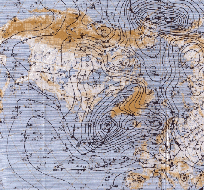
Fig 2. Surface analysis at 12 UTC on 28 Nov 1998. The background map shows the oceans and topographical heights.

Fig 3. 200 hPa analysis at 12 UTC on 28 Nov 1998.
Potential vorticity conservation
A combination of the momentum conservation equation and first law of thermodynamics shows that the potential vorticity can only be changed by diabatic heating or friction. The amount of potential vorticity possessed by an airmass is therefore a handy way of earmarking it, unaffected by changes of elevation, latitude or shear. The conservation of potential vorticity is the air's equivalent of the conservation of angular momentum. When a spinning ice skater has her arms spread out laterally, she spins slowly. When she contracts her arms, her rate of spin accelerates. Similarly, the vortex of air on the left in Fig 4 is broad and slow. When the air converges, the column stretches, i.e. Dq increases. To maintain potential vorticity, the air spins faster (x increases), resulting in the streched vortex on the right. Divergence, on the other hand, causes vortex spreading and slows down the rate of spin.
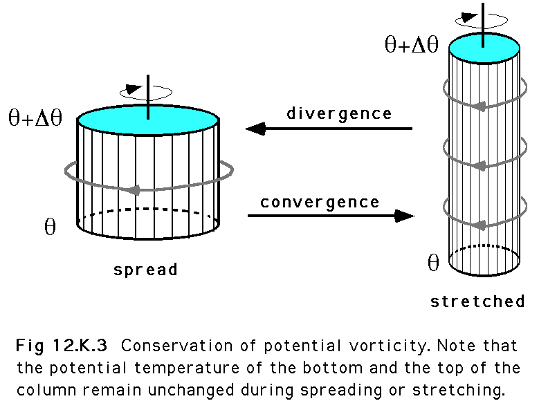 Fig 4
Fig 4
Application to airflow over a mountain range
The conservation of potential vorticity explains how mountain chains such as the Andes can induce Rossby waves (Fig 5). As the air flows over the mountain, the potential temperature is conserved, so the 300K isentrope (q in Fig 5) bends over the mountain. Air aloft, at the 320K isentrope (q+Dq in Fig 5), is lifted much less as it passes the range. Therefore Dq is reduced over the mountain chain, and to keep the potential vorticity h constant, the absolute vorticity f + z must be reduced equally.
Since f is approximately constant, the flow must assume negative vorticity or anticyclonic turning, i.e. counterclockwise turning in the southern hemisphere. By the same token, on the lee side, the expansion of the isentropic layer demands positive vorticity or clockwise turning. A ridge over mountains and a trough in its lee are often observed. Below the upstream side of the trough a low may form and intensify at the surface (Note 12.L). This process is called lee cyclogenesis and explains why midlatitude cyclones form in the lee of mountain ranges, e.g. to the east of New Zealand and southern South America (Fig 6). These lows or troughs are responsible for most of the rainfall along the coast.
Further downstream, the flow, now heading to the southeast, will experience an increase in planetary vorticity. In the absence of other mountains (i.e. Dq is now constant), this invokes a reduction in z, hence the cyclonic curvature changes to anticyclonic curvature, and the flow heads northeastward again: a Rossby wave has been formed (Fig 5).
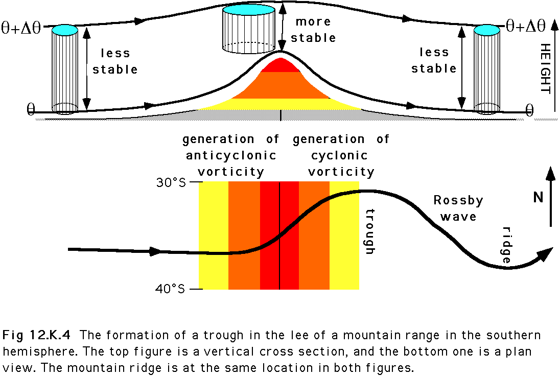 Fig 5
Fig 5
 Fig 6
Fig 6