|
E. Linacre and B. Geerts |
10/'98 |
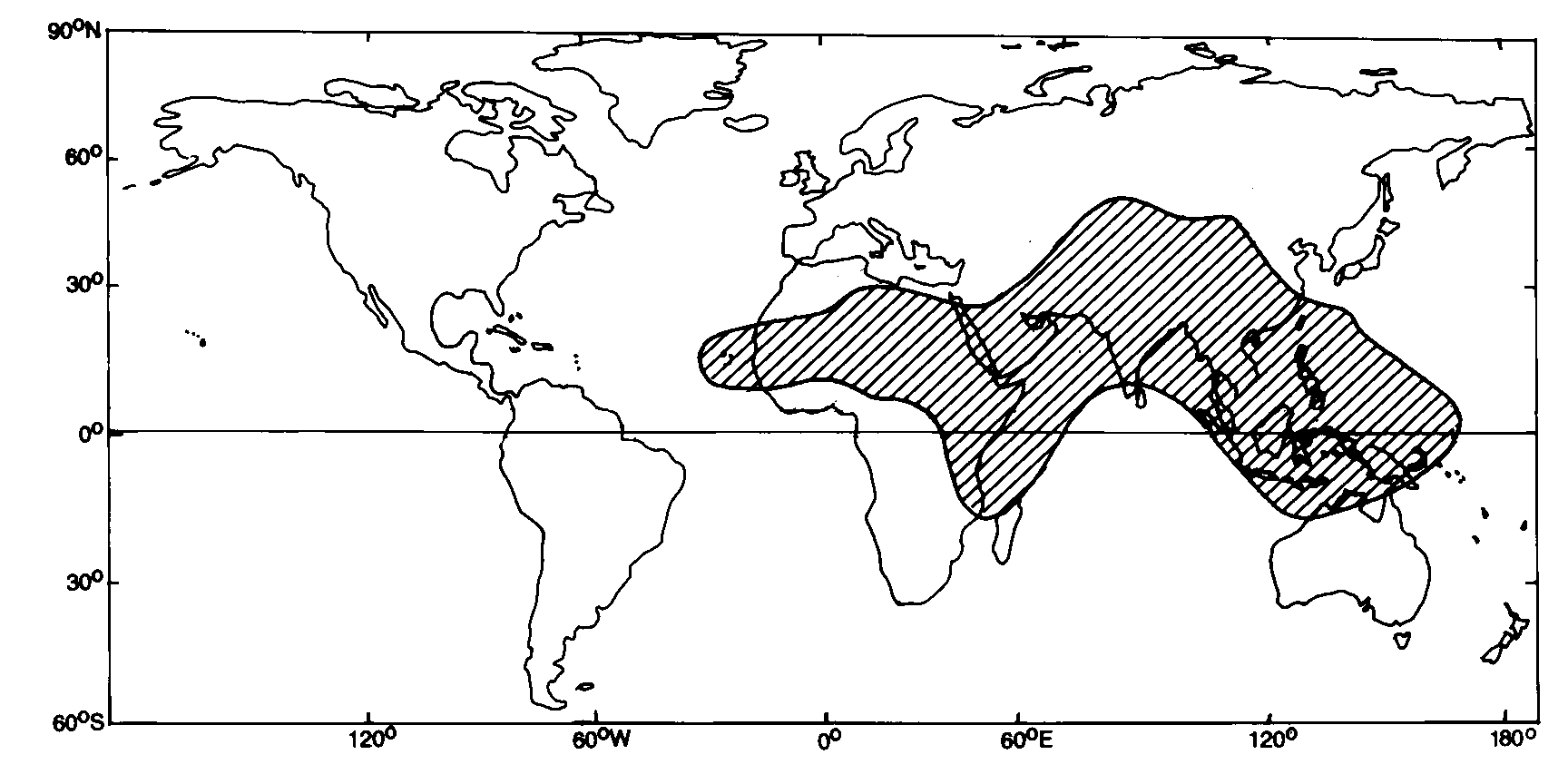
Most low-latitude regions have a clear cycle of a dry and wet, usually during the winter and summer, respectively. The wet season is often referred to as the monsoon, especially in Southeast Asia, but also in northern Australia and the Sahel region of Africa, and even in the Amazon Basin, the southwestern USA, and the plateaux of eastern and southern Africa. Strictly speaking, a monsoon is defined by a seasonal change in wind direction, in particular, monsoonal areas (Fig 1) feature all of the following (1,2,3) -
Fig 1. Regions affected by monsoon winds.
|
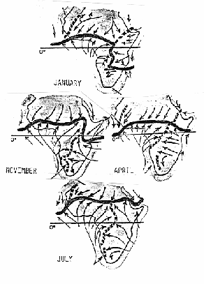
The monsoonal areas lie almost entirely east of zero longitude, and north of the equator except for the east coast of Africa, Indonesia and northern Australia. The reason for this is the huge landmass of Eurasia. A massive low-pressure system forms over south Asia in summer, and in winter it is substituted by a strong high centered over Siberia. Because a change of wind direction implies a change of rainfall regime in almost all monsoonal regions, the two seasons are often referred to as the wet monsoon (or monsoon for short) and the dry monsoon. If the four criteria mentioned above are not satisfied, but there is a distinct wet season during or shortly after the high sun (i.e. the summer), then that rain regime is zenithal (i.e. when the sun is near the zenith). At low latitudes, equatorward of the axis of the subtropical highs, the rainfall is largely controlled by the Intertropical Convergence Zone (ITCZ). In Africa, for instance, the rainfall follows the ITCZ, which follows the Sun more or less between the Tropic of Capricorn and Cancer (Fig 1). Clearly there are departures, due to the shape of the continent and the topography. There are also spurring convergence lines, such as the Zaire Airmass Boundary, separating air from the Atlantic Ocean from that from the east, mainly during the southern summer. Monsoonal rains too are controlled by the poleward movement of the ITCZ over continents. Therefore a clear distinction between zenithal and monsoonal rain is somewhat academic. But near the equator some regions, such as the western Amazon basin and the Zaire Basin, have two wet seasons, at are just after each equinox. Clearly these rains are zenithal. Monsoonal regions of course have only one wet season per year.
|
Fig 2. The annual cycle of the average position of the ITCZ (bold) and other convergence lines (dashed lines). The streamlines (lines with arrows) indicate the source regions of the air converging to the boundaries, not the average surface wind directions. |
References
(1) Sturman, A.P.and N. Tapper 1996. The Weather and Climate of Australia and New Zealand (Oxford) 476pp.
(2) Ramage, C.S. 1971. Monsoon Meteorology (Academic Press) 296pp
(3) Hastenrath, S. 1988. Climates and Circulation of the Tropics (Reidel) 455pp.