Sea surface temperature measurement
|
E. Linacre and B. Geerts |
1/'99 |
![]()
Sea surface temperatures are measured by vessels and floating or fixed buoys. These in situ measurements are quite accurate but provide limited spatial coverage. The SST distribution is largely derived from remote observations. The main instrument is the Advanced Very High Resolution Radiometer (AVHRR), which is aboard several NOAA polar-orbiting satellites (1). This multi-spectral instrument is also used to derive temperature profiles, examine land surface conditions, and study cloud characteristics. The SST can only be estimated under clear conditions. About 150,000 SST estimates are made each day around the globe, and the estimates are fine-tuned by correlations with in situ observations. The resulting monthly-mean global SST field has bias errors less than 0.1 K, and a root-mean-square difference of only 0.6 K from measurements obtained with floating buoys (1).
AVHRR-based SST estimation is only possible under clear skies. Also, the swath (angle of view) of the AVHRR instrument is only 2000 km. Therefore a composite image is often derived, incorporating all SST estimates from all orbits during a certain period, e.g. 5 days (Fig 1). Even after 5 days some pixels lack a SST estimate because the AVHRR did not get to see the ocean there.
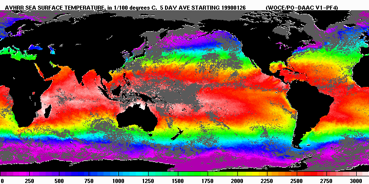
Fig 1. Composite AVHRR-based SST estimate between 26-31 Jan 1990. The grey pixels were either always cloudy or ice-covered during satellite overpass (Source: World Ocean Circulation Experiment Satellite Data CD-ROM).
Reference
(1) May, D.A., M.M. Parmenter et al. 1998. Operational processing of satellite sea surface temperature retrievals at the Naval Oceanographic Office. Bull. Amer. Meteor. Soc., 79, 397-407.