Towards a rainfall-based hurricane intensity classification
|
B. Geerts |
2/’02 |
![]()
Tropical cyclone intensity is classified in
terms of the maximum sustained wind near the surface in the eyewall. The
Saffir-Simpson intensity scale ranges from 1-5 (Table 13.2), analogous to the
Fujita intensity scale for tornadoes. The criterion for this classification is
justified both in terms of storm dynamics and potential hazard. The wind speed
is directly related to the minimum sea-level pressure, which explains the sea
level surge.
Some recent events have illustrated that
weak tropical cyclones or tropical depressions can produce abundant rainfall,
especially if these storms are remnants of much stronger systems. In 1970 a
decaying tropical cyclone slowly moved from the Bay of Bengal over the
Ganges/Brahmaputra river delta of Bangladesh. An estimated 600,000 people died,
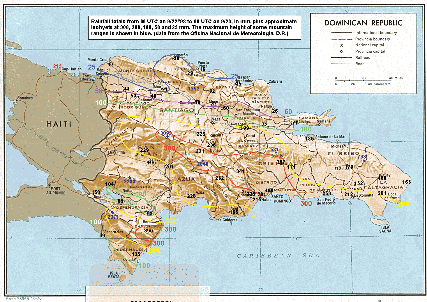
mainly by drowning. On 22 September 1998 hurricane Georges (cat 2) dumped over 400 mm of rain on the south coast of the Dominican
Republic, the bulk of it in less than 12
hours, after it had been downgraded from a cat 4 cyclone (1). And two months
later tropical storm Mitch dropped over 800 mm of rain in parts of Honduras and
Nicaragua in 48 hours, after it was rapidly downgraded from a cat 5 cyclone. In
this storm over 10,000 people died, mainly as a result of flashfloods, and the
region's infrastructure and agriculture were extensively damaged. The message
that this ominous storm so close to the coast was rapidly decaying may have
resulted in a lower level of activation of the emergency response system.
The conclusion is that landfalling tropical
cyclones, even tropical storms, can produce torrential rains, especially if
they are the remnants of a much stronger circulation. Floods are likely,
especially if the storm moves slowly. A classification scheme that quantifies
the rainfall threat of tropical cyclones would be useful. This scheme should be
based not only the storm's dynamic intensity (i.e. the Saffir Simpson scale),
but also its history, its projected movement, and perhaps its size.
Reference
(1) Geerts, B., G.M. Heymsfield, L. Tian, J.B. Halverson, A. Guillory, and M.I. Mejia, 2000: Hurricane Georges' landfall in the Dominican Republic: detailed airborne Doppler radar imagery. Bull. Amer. Meteor. Soc., 81, 999-1018. (abstract)