|
E. Linacre |
2/'98 |
![]()
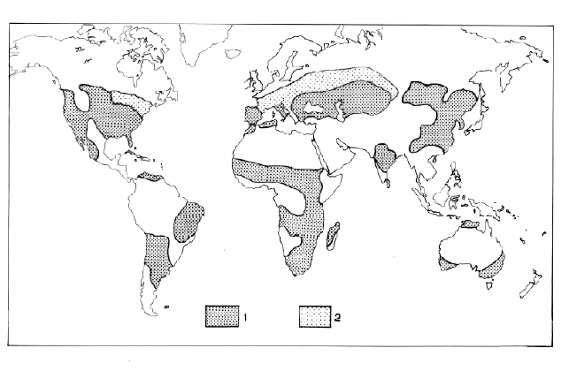
The map below shows the vulnerability of major agricultural areas to drought, on the basis of the difference between annual precipitation and potential (lake) evaporation (1). The heavily shaded areas (numbered '1' in the key) have frequent intensive droughts, with differences of 10-500 mm, whilst areas numbered '2' have fewer and less intensive droughts. The diagram is based on work by Goldsberg (1972). Deserts are excluded because drought conditions are perennial there.
There is no single cause of an anomalous lack of rain. Droughts in the mid-latitudes are due to a prolonged presence of warm, dry air in the middle tropophere, with prevailing widespread subsidence and surface high pressure regions (2). Such highs tend to form equatorward and just eastward of a long wave ridge in the upper westerlies circling the globe. Dry summers in the USA tend to follow warm dry springs, and show some dry summers persistence from year to year. In some areas droughts are associated with the El Niño Southern Oscillation.
References: