|
B. Geerts and E. Linacre |
3/'98 |
Northwest cloud bands are an important feature of weather in the subtropical belt of the southern hemisphere. These bands are 3,000 to 8,000 km long, and connect a cold front at their southeastern end to the ITCZ at their northwestern end. Usually an easterly wave (Note 13.H) is present at the equatorial end of the NW cloud band. The South Pacific Convergence Zone often connects to a NW cloud band.
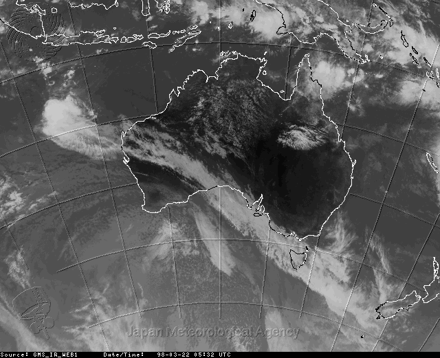
NW cloud bands also occur over S. Africa and more commonly near S. America, from Paraguay into the South Atlantic (1). The latter is known as the South Atlantic Convergence Zone. Around Australia, NW cloud bands typically stretch from near Indonesia, across central Australia to the southeast coast (2). NW cloud bands may occur any time of the year, and they are the main source of winter rainfall in the northern half of Australia. An example is shown in Fig 1.
Fig 1. Geostationary Meteorological Satellite IR image on 22 March 1998 at 5:32 UTC.
The cloud band arises from a combination of circumstances. At the northern, tropical end, the clouds are deep and convective, drawing considerable moisture into the upper atmosphere. The lower troposphere is uniformly warm and humid. The convection is focused along the NW cloud band because the trade wind inversion is locally weaker. This is due to mid-tropospheric ascent, which usually is associated with an easterly wave.
Following the band towards the southeast, the convection diminishes or disappears, and the NW cloud band typically has a high cloud base. Here, near the axis of the subtropical highs and prevailing large-scale subsidence, the equatorial tail of a westerly wave is found in the upper troposphere. The moisture is the result of a mid- to upper level ‘warm conveyor belt’ advecting heat and moisture of tropical origin into the frontal system to the southeast. The cloudiness is sustained by upper-level divergence ahead of the westerly wave trough. Sometimes the cloud band moves overhead without producing rain at the surface.
Further south the NW cloud band assumes the typical surface and upper-level characteristics of a cold front. Even in central and northern Australia, the passage of the tail end of a cold front can be felt at the surface, mainly in late winter (3). The typical wind shift and the pressure check of a cold frontal passage occur. Because the lower atmosphere is too dry in winter in the northern half of Australia, clouds are absent or they are limited to the middle and upper troposphere, i.e. the NW cloud band.
NW cloud bands are an important component in the interaction between the ITCZ and the mid-latitude frontal belt. A northern-hemisphere equivalent (a SW cloud band) exists, but it is more frontal along its entire length. SW cloud bands are most pronounced in winter from Central America to the US east coast and from Indochina to Japan.
References
(1) Preston-Whyte, R.A. and P. Tyson, 1988. The atmosphere and weather of Southern Africa (Oxford University Press) 375 pp.
(2) Tapper, N. & L. Hurry 1993. Australia’s Weather Patterns: an introductory guide (Dellasta Pty Ltd, Mt Waverley, Vic.) 130pp.
(3) Smith, R.K., M.J. Reeder, N.J. Tapper, and D.R. Christie, 1995. Central Australian cold fronts. Mon. Wea. Rev., 123, 16-38.