Cloud liquid water content, drop sizes, and number of droplets
|
E. Linacre and B. Geerts |
8/'99 |
The cloud liquid water content (LWC) can be expressed either in g/m3 or g/kg. It varies greatly from cloud to cloud. Convective clouds have a higher LWC than stratiform clouds. For convective clouds, the LWC increases with height (up to the level of glaciation) and it is higher when the cloud base temperature is higher. Maritime clouds generally have fewer but larger drops than continental drops, because there are fewer cloud condensation nuclei in the maritime troposphere. The maritime boundary layer is often so depleted of CCN that ship tracks sometimes can be detected by a trail of cloud (or thicker cloud). This increases the planetary albedo, which may affect climate (1).
Theoretical cloud LWC
Simple calculations (2) show that the LWC in a convective cloud increases with increasing cloud base temperature and with height above the cloud base. These calculations assume an undiluted, non-precipitating, rising parcel of air. Table 1 also shows that the fraction of water that has condensed (or is frozen) is greater, the higher the parcel rises and the lower the cloud base temperature. In reality, at least some of the condensation material will convert from cloud material (droplets or ice crystals) to precipitation (rain, snow or hail),which falls out of the ascending air parcel. Therefore the condensed amounts listed in Table 1 tend to be an overestimate, especially at higher elevations and when the updraft is less vigorous.
|
Table 1. Computed amounts of moisture in either non-vapour or vapour forms in a undiluted, non-precipitating ascending cloud parcel (i.e. the temperature and dewpoint are determined by the moist adiabatic lapse rate). The cloud base is assumed to be at 1 km (2). V = water vapour; LI = liquid and/or frozen water, both in g/m3. For instance, there are 5.5 g/m3 of droplets and 11 g/m3 of water vapour at 4 km elevation (and 7ºC) within a non-precipitating cloud parcel whose temperature at its condensation level (at 1 km elevation) was 25ºC.
|
cloud base temperature
(°C) |
elevation (km) |
|
1 |
2 |
4 |
7 |
10 |
|
V |
LI |
V |
LI |
V |
LI |
V |
LI |
V |
|
25 |
24 |
2.2 |
20 |
5.5 |
11 |
7.7 |
4.3 |
7.3 |
0.5 |
|
15 |
13 |
2.0 |
9.6 |
4.6 |
4.9 |
5.8 |
1.2 |
|
|
|
5 |
6.8 |
1.7 |
4.6 |
3.3 |
1.5 |
3.6 |
0.2 |
|
|
|
- 5 |
3.2 |
1.2 |
1.7 |
1.9 |
0.4 |
1.9 |
0.1 |
|
|
Observed cloud LWC: maritime vs. continental
In reality the LWC in clouds is lower (Table 2), in part because of mixing with the ambient dry air, in part because of precipitation falling out of the cloud. Table 2 shows that marine clouds typically have fewer droplets than continental clouds of the same type. Yet marine cloud droplets are larger, hence the LWC is about the same in both environments. Stratus and cumulus clouds, albeit of very different origin, have about the same LWC, but the (equivalent) LWC of cirrus clouds is at least an order of magnitude smaller.
Table 2. Observed typical values for the properties of clouds. The values are merely modal-means. The range of observed values is quite large. The radius of cloud droplets is r (microns), the effective optical radius optically is r', N is the number of droplets per cubic centimetre, L is the liquid water content of the cloud (g/m3). For all clouds, the level of observation is just below the freezing level, except for fog and cirrus. Cirrus consists entirely of ice crystals, and the values shown in this table are liquid equivalents (Source: (3,4)).
|
environment |
cloud-type |
r |
r' |
N |
L |
|
continental |
stratus |
4.7 |
7.3 |
250 |
0.28 |
|
cumulus (clean) |
4.8 |
5.8 |
400 |
0.26 |
|
cumulus (polluted) |
3.5 |
4.0 |
1300 |
0.3 |
|
cumulonimbus (growing)* |
6-8 |
7-10 |
~500 |
1-3 |
|
cumulonimbus (dissipating)* |
7-8 |
9-10 |
~300 |
1.0-1.5 |
|
fog |
8.1 |
10.7 |
15 |
0.06 |
|
maritime
|
stratus |
6.7 |
11.3 |
80 |
0.30 |
|
(strato)cumulus |
10.4 |
12.7 |
65 |
0.44 |
|
continental or maritime |
cirrus (-25° C) |
- |
92 |
0.11 |
0.03 |
|
cirrus (-50° C) |
- |
57 |
0.02 |
0.002 |
* based on in situ and satellite measurements over Indonesia, Thailand and Israel (4).
The transition from 'continental' to 'maritime' usually is gradual. When a cloud is advected over land by an onshore breeze it begins to change, acquiring the properties of a continental cloud after a few tens to several hundred kilometres. It takes longer for the transition when continental cloud moves offshore, i.e. pollution is quicker than cleansing. The transition distance is longer when the boundary layer is stably stratified, reducing the coupling between the source of the most CCN and the cloud layer.
Measurements in the cloud at 3210 m in the northwestern Colorado Rocky Mountains also show an inverse relationship between droplet size and concentration, i.e. larger droplets mean fewer. In other words the total water content of clouds varies less than the droplet size spectra (5). For instance, a large number of samples shows that are about 150 droplets per cubic centimetre if the median diameter is 17 microns, but 700/cm3 if only 10 microns. The total water content in both situations is about the same. Trajectory analysis and in-situ sampled aerosol indicate that larger droplets tend to occur in clouds of maritime origin, i.e. in air advected from the Pacific Ocean in a frontal disturbance, whereas smaller droplets are usually found in cumulus clouds generated in an airmass more adjusted to the continental environment.
Observed cloud LWC: variations with altitude
The LWC also depends on altitude in a cloud. Cirrus contains much less water than stratus, for instance. Five possible zones can be distinguished within a deep-convective cloud, with glaciation in the topmost, an ice and droplet mixture in the next, then a 'rainout' layer, below which was a zone of rapid droplet growth by coalescence of droplets above 0°
C, and then at the base a zone of very slow growth by diffusion (4). 'Rainout' occurs in a zone where the effective radius is stable at about 20-25 micron, and droplet growth by coalescence is balanced by loss of the larger droplets downwards.
In the maritime cloud, the second layer of a mixture of phases is only shallow, and there is no layer of diffusion growth. A continental cloud has a deep layer of diffusional growth and sometimes little coalescence zone. Glaciation occurs in maritime clouds at temperatures above -10°
C, whereas in continental clouds only when temperatures are below -15°
C, or even below - 30°
C. Coalescence and thus precipitation can be suppressed by increasing the CCN count, e.g. by burning forests or by industrial emissions, even with deep tropical clouds.
|
In stratiform clouds, the LWC is as much as 10 times lower than in deep convection. Above the freezing level, the supercooled LWC is even lower, but occasionally it is fairly large, which is hazardous to aviation. A compilation of over 1000 hours of flight through stratiform clouds by the University of Wyoming's research aircraft provides some insight as to typical LWC values in supercooled stratiform clouds (6). Fig 1 illustrates the frequency distribution of all these measurements. The vast majority of these cases have quite low LWC (less than 0.1 g/m3) with only about 17% of the cases having LWC greater than 0.3 g/m3.
|
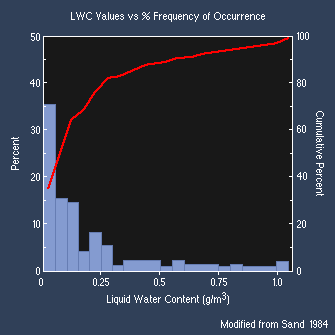
Fig 1. Histogram of liquid water content (LWC) in a large sample of stratiform clouds at temperatures below 0ºC (6). |
References
- Radke, L.F., J.A. Coakley and M.D. King, 1989. Direct and remote sensing ovbservations of the effects of ships on clouds. Science, 246, 1146-9.
- Lamb, H.H. 1972. Climate; Past, Present and Future (Methuen) 357pp.
- Hess, M., P. Koepke and I. Schult 1998. Optical properties of aerosols and clouds. Bull. Amer. Meteor. Soc.,79, 831-44.
- Rosenfeld, D. and I. M. Lensky 1998. Satellite-based insights into precipitation formation processes in continental and maritime convective clouds. Bull. Amer. Meteor. Soc., 79, 2457-76.
- Borys, R.D. and M.A. Wetzel 1997. Storm Peak Laboratory. Bull. Amer. Meteor. Soc., 78, 2115-23.
- Sand, W., W. Cooper, M. Politovich, and D. Veal, 1984. Icing conditions encountered by a research aircraft. J. Climate. and Appl. Meteor., 28, 856-868.