Tornado nowcasting
|
E. Linacre and B. Geerts |
6/'98 |

In meteorology nowcasting refers to short-term weather prediction solely by means of current information, without the aid of numerical models. Nowcasting is a potentially useful technique to anticipate tornadoes: the advancement of a tornado warning by just a few minutes can save many lives. Tornadoes usually catch forecasters by surprise, even today when high-resolution satellite and radar imagery is available. The reason for the poor predictability of tornadoes is twofold:
- Thunderstorm development, intensity and evolution cannot be predicted with the current generation of numerical weather prediction models, and it is unlikely that this will change in the next few decades. The problem is primarily due to lack of high-resolution data. However the environment in which (severe) thunderstorms can develop is fairly predictable.
- Current observing systems, such as satellite imagery and especially Doppler radar, do not readily discriminate between a tornadic and a non-tornadic thunderstorm. Of particular interest are early signs of a tornadogenic storm in the remote imagery.. There are some clues, but they only slightly increase the probability of remote detection.
Clearly, both numerical predictions and nowcasting of tornadoes benefits from higher-resolution observation platforms. In the USA, where violent tornadoes are more common than anywhere else, a dense network of Doppler radars has been installed during 1987-'97, in part to improve the predictability of severe weather. The following facts apply to the USA (1):
- Less than 1% of thunderstorms generate a tornado.
- There are about 800 tornadoes reported each year in the USA (ranging from 500 to 1,300), of which 83% are regarded as weak (F0), 15% as strong (F1-F2) and 2% as violent (F3-F5).
- Weak tornadoes last less than 10 minutes, with paths less than 1.6km long and 100m wide. Wind speeds are typically 50 m/s. They account for less than 5% of tornado fatalities and damage.
- Violent tornadoes last from 10 minutes to over 2 hours. An outbreak may consist of a series of tornadoes, each lasting tens of minutes. The path may be nearly continuous over 160 km or so, and 1 km wide, but usually is discontinuous. The maximum observed swath width is 2.5 km. Violent tornadoes produce damaging winds, up to 125 m/s, and large hail often occurs nearby, usually to the north. Almost all violent tornado paths are from southwest to northeast.
- Opening windows does not reduce the damage of a tornado to a house. This contradicts an old advisory which was based on the assumption that most damage results from the pressure difference between inside and outside, when a tornado passes over a house (Note 7.J).
- Sometimes the formation of a tornado is preceded by mesocyclones within the parent storms. These mid-level cyclonic circulations are large enough to be seen by Doppler radar at a distance of 100 km or more. They tend to develop 15-30 minutes before the tornado touchdown (Fig 1). Only about one in three mesocyclones (detected by Doppler radar) are tornadic. They are more likely to spawn a tornado when they are deeper, longer-lived, and have a lower base and a higher vorticity. The advent of the network of Doppler radars in the USA has increased the lead time for tornado warnings. An example of a Doppler radar view of several supercell storms is shown in Fig 2(a). The corresponding radial velocity is shown in Fig 2(b). Mesocyclones can be seen as small red-green dipoles superimposed on the ambient airflow.
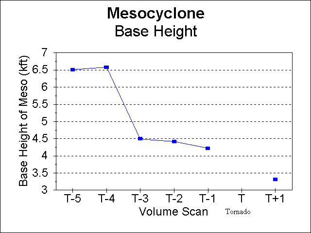
Fig 1. Typical evolution of the base height of a mesocyclone prior to touchdown (T) of a tornado. Time is expressed in terms of volume scans, which are completed in about 5 minutes. The rapid downward extension of the mesocyclone base height, typically about 15 minutes prior to tornado touchdown, is used as an argument to issue a tornado warning. (Source: Operational Support Facility, National Weather Service)
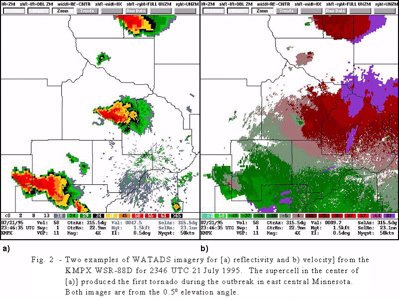
Fig 2 Supercell storms in Minnesota, as seen by Doppler radar. The black contours outline the counties. The picture represents an area of about 120 by 150 km. The radar is located in the southeastern quadrant, in the center of some ground clutter seen in the reflectivity image (a). On the right (b), green colours indicate flow towards the radar, red means flow away from the radar. (Source: Operational Support Facility, National Weather Service)
Reference
(1) AMS 1997. Policy statement on tornado forecasting and warning. Bull. Amer. Meteor. Soc., 78, 2659-62.