|
E. Linacre and B. Geerts |
1/'99 |
![]()
|
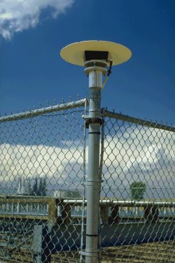
The Global Positioning System (GPS) is a network of numerous satellites, used to determine ones three-dimensional position relative to the Earth. A GPS unit receives radio waves from at least three satellites, and the time of arrival of these waves allows determination of the unit's location through triangulation. Radio waves of about 19 or about 22 cm wavelength are transmitted from the current constellation of 24 satellites orbiting at about 20,000 km elevation, which enable locations on Earth (or aloft) to be fixed to within 0.5 m. The system was originally designed and built by the US military, but a degraded version was released for commercial use. Small, even handheld units are now available at low cost (Fig 1), and because of the large number of GPS satellites, their accuracy is better than that originally achieved by the military.
Fig 1 (right): A GPS receiver mounted on the corner fence post of the Platteville Colorado wind profiler; it was positioned there for comparison of GPS precipitable water to that measred by other instruments (click here for a wider view of the same). |
|
Ingenious use can be made of the GPS to determine the amount of water vapour in the atmosphere (1). There are two aspects to this, each based on the delay in the transmission of radio waves through the atmosphere. Water vapour contributes to this delay, and since it is the only significant atmospheric constituent of variable concentration, its concentration along the radio beam can be inferred.
Ground-based method
The first, most widely used technique uses a GPS receiver on the ground. This does not allow an estimation of the vertical profile, only the vertically integrated amount, i.e. the precipitable water. A correction is made for the fact that the radio beams normally are slanted from the zenith. This ground-based GPS water vapour estimation is not affected by rainfall and clouds, and can therefore be called an 'all-weather' system. As it takes minor effort to obtain GPS water vapour estimates from the existing GPS infrastructure, and since the temporal and spatial resolution are higher than of radiosondes, GPS water vapour estimation is a valuable complement. A comparison with radiosonde data is shown in Fig 2.
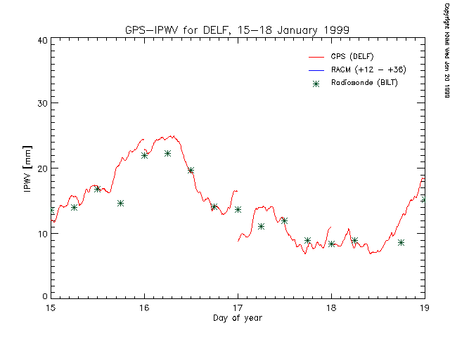
Fig 2. A 4-day comparison between precipitable water (IPWV) derived from radiosondes (*) and that from a GPS receiver (red curve) in the Netherlands. The discontintinuities in the GPS estimate are due to a change of satellites used in the calculations; these are partly real because at least one different slant beam is used, so different air is sampled. (source: GPS water vapour meteorology)
Occultation method
The second technique involves signals to another satellite circling the Earth at only 775 km, carrying a GPS receiver. The signals traverse the troposphere at various elevations during the 60 seconds prior to the lower satellite losing contact by going behind the Earth, i.e. whilst ‘occultation’ occurs. The various amounts of water vapour at different elevations imply different delays (known as ‘wet delays’), so there is overall bending of the signals, which prolongs contact with the low satellite for a little beyond visual occultation. The delayed signal is measured at each moment, and then it is possible to deduce the profile of water vapour. Further analysis of the data also gives a temperature profile (e.g. the height of the tropopause), but with less accuracy. The procedure of radio occultation has also been used to derive atmospheric profiles of planets (2).
References
(1) Businger, S., S.R. Chiswell, M. Bevis, J. Duan, R.A. Anthes, C. Rocken, R.H. Ware, M. Exner, T. Van Hove, and F.S. Solheim, 1996. The promise of GPS in atmospheric monitoring. Bull. Amer. Meteor. Soc., 77, 5-18.
(2) Melbourne, W.G. et al. 1994. The application of space borne GPS to atmospheric limb sounding and global change monitoring. JPL Publ., 18, 147pp.