|
E. Linacre |
12/'98 |
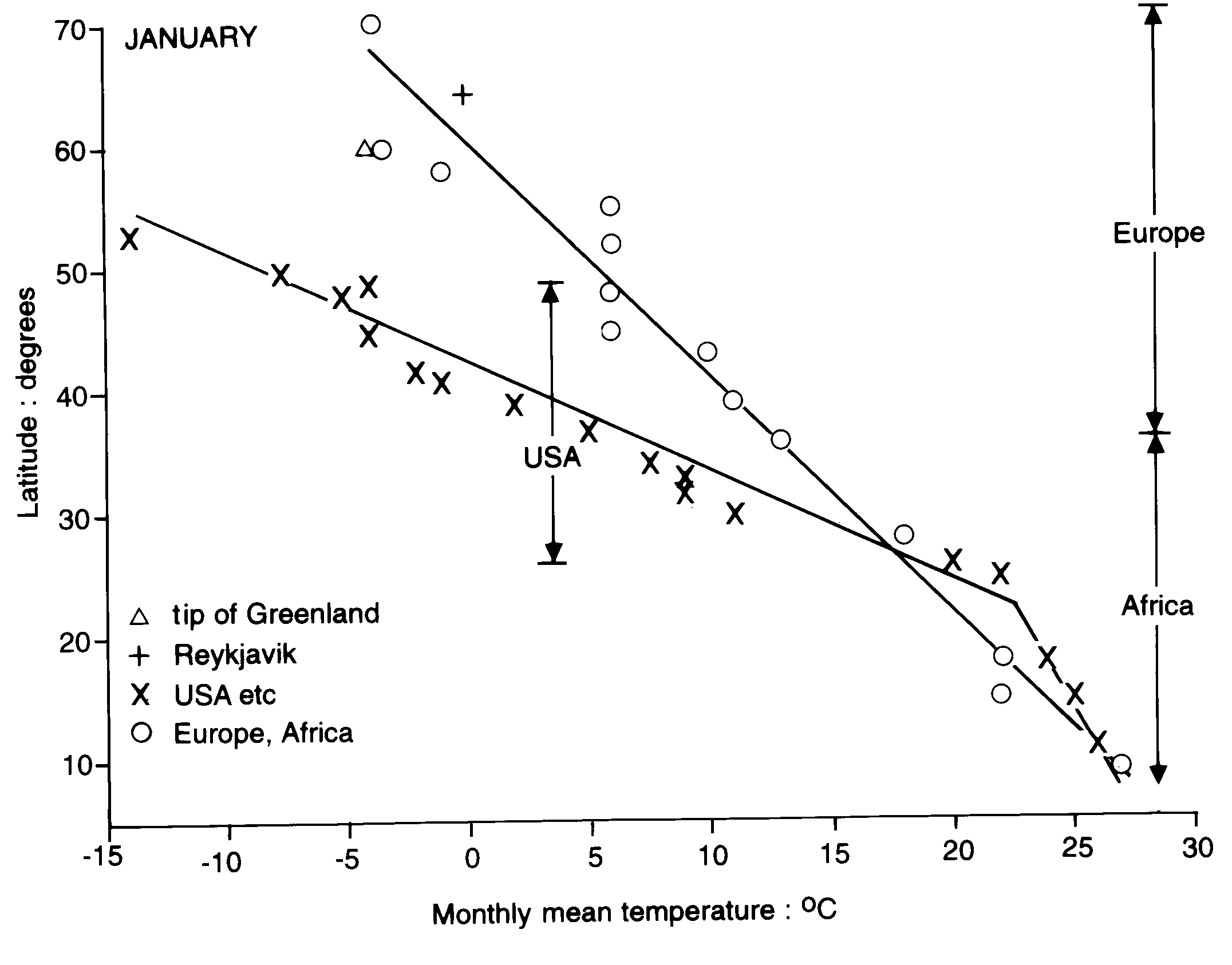
The mean temperature on the western border of the Atlantic Ocean is much lower than on the east (European) side north of 40ºN, especially in winter (Fig 1). However in summer, between 15-45ºN, it is warmer on the American side (Fig 2). There are two reasons for the divergence, the Gulf Stream and the nature of the surface upwind. The Gulf Stream bears warmth along the Atlantic south coast of the USA, but at Cape Hatteras (35°N) it leaves the continental margin and crosses the Atlantic towards the UK., and then the westerly winds that prevail at mid-latitudes are affected and carry the warmth over Europe. The cold Labrador current keeps the Atlantic coast of North America north of Cape Hatteras cool, especially in winter.
Another factor is the prevailing wind: because of the westerly winds, the northeastern USA experiences a more 'continental' climate than northwestern Europe. The northeastern USA is influenced by the vast land mass upwind, as well as polar winds channeled south by mountain ranges. Land surfaces cool well below sea-surface temperatures in winter, whereas the latter change relatively little from one season to the next, unless sea ice forms. As a result, the annual mean temperature on the coast of Canada around 60° N is about 10 K lower than the temperature at Bergen, at about the same latitude, chiefly on account of lower winter temperatures. The same difference is found between east and west coasts in North America, although not as large.
A third and minor factor is the upwelling along the west coasts of Portugal and the Sahara, and the cold Canary current in the same region. This upwelling is largely a summertime phenomenon, because the Azores high is stronger in summer. This explains the lower temperature on the eastern boundary, compared to the American side of the Atlantic, south of 30°N in winter and (more significantly) south of 45°N in summer (Fig 2).
Fig 1. January mean temperatures at places on opposite coasts of the Atlantic Ocean. The points shown by diagonal crosses relate to the western boundary of the ocean (on the coast of North America), whilst circles represent places along the European and African coasts. A triangle relates to the southern tip of Greenland, and a vertical cross to Reykjavik in Iceland. The data come from various sources (1).
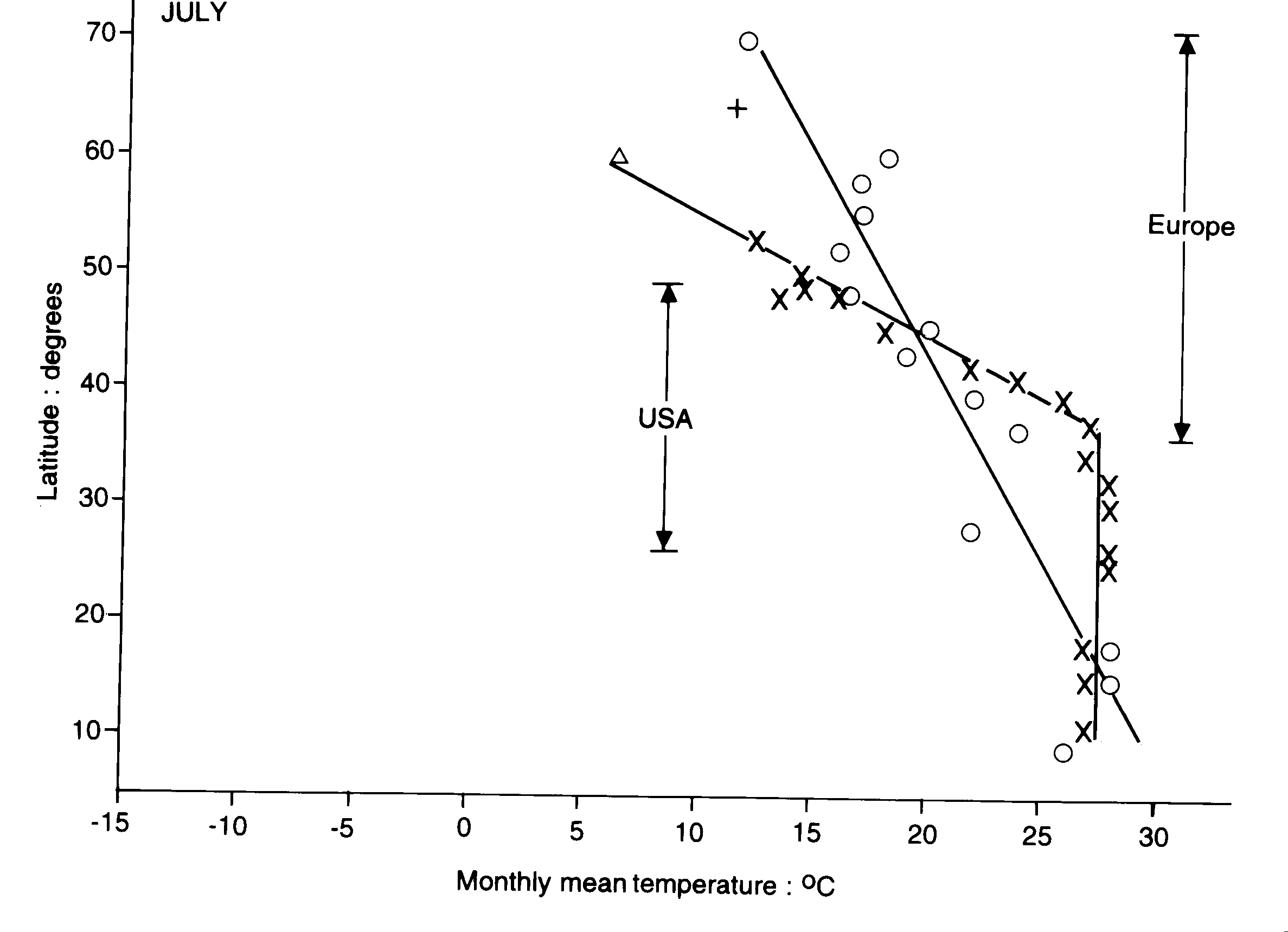
Fig 2. As for Fig 1 but for July, i.e. summer.
It can be seen that temperatures at Reykjavik at 64°N in Iceland vary as though it is on the coast of Europe, being equally warmed by the Gulf Stream. The same seems to apply to the tip of Greenland in winter, but not in summer. Temperatures there in summer are lowered by cold waters to the west, in the Hudson Bay and Davis Strait.
The difference between east and west in winter is even larger across the Pacific Ocean, between 45-60ºN. The world’s largest annual temperature range is found at Verkhoyansk at 68°N in eastern Siberia, north of Manchuria. The average in January is minus 51°C, whilst July temperatures is about 13°C, i.e. a range of 64 K. The highest temperature ever recorded there was 28°C. Daily ranges average just 5 K (January) and 11 K (July). On the other side of the Pacific, Anchorage Alaska (61°N) has a January and July mean temperature of -11°C and14°C, respectively.
References