Surface temperature in Antarctica
|
E. Linacre and B. Geerts |
6/'99 |
![]()
Antarctica’s geography
The continent consists of three parts, East Antarctica, West Antarctica and the Antarctic Peninsula, Fig 1. Their areas are respectively 10, 2.0 and 0.5 million square kilometres. Most of East Antarctica is above 3000 m above sea-level, rising to exceed 4 km in a small area at about 82° S/ 80° E, though the highest point in Antarctica is the Vinson Massif at 5,440 m in West Australia. The high land in East Antarcica is known as the Antarctic Plateau, where the ice is more than 2 km thick. The average elevation of the continent is 2.2 km, far above the 700 m for other continents. Therefore atmospheric pressures at the South Pole (at 2,800 m) are about 680 hPa, and at Vostok (3,500 m) about 620 hPa.

Fig 1. Geography and precipitation of Antarctica. The dashed line shows the extent of permanent ice.(1)
The volume of the ice sheet over Antarctica is now about the same as that of the ice over North America during the last Ice Age. Apart from the inland ice there is sea ice, and ice shelves in relatively shallow bays. The Ross and the Filchner-Rome ice shelves are each the size of France.
Surface temperature
Antarctica is extremely cold. The extreme temperatures at the permanently-manned South Pole station are -14 to -81°C, and at Vostok -21 to -89°C. Near the coast above-freezing temperatures occasionally occur, and they are common on the Palmer Peninsula. But the annual mean is below 0°C everywhere (Fig 2). There is some similarity between the map of surface annual mean isohyets (Fig 16.4) and the pattern of annual mean temperatures in Antarctica. Temperatures of around - 25° C around the coast correspond to precipitation of around 400 mm/a, while about 50 mm/a fall on the Plateau, where temperatures average -55° C or so (1). The eightfold difference of precipitation is due partly to the 30-fold ratio of saturation vapour pressures (over ice) at the two temperatures.
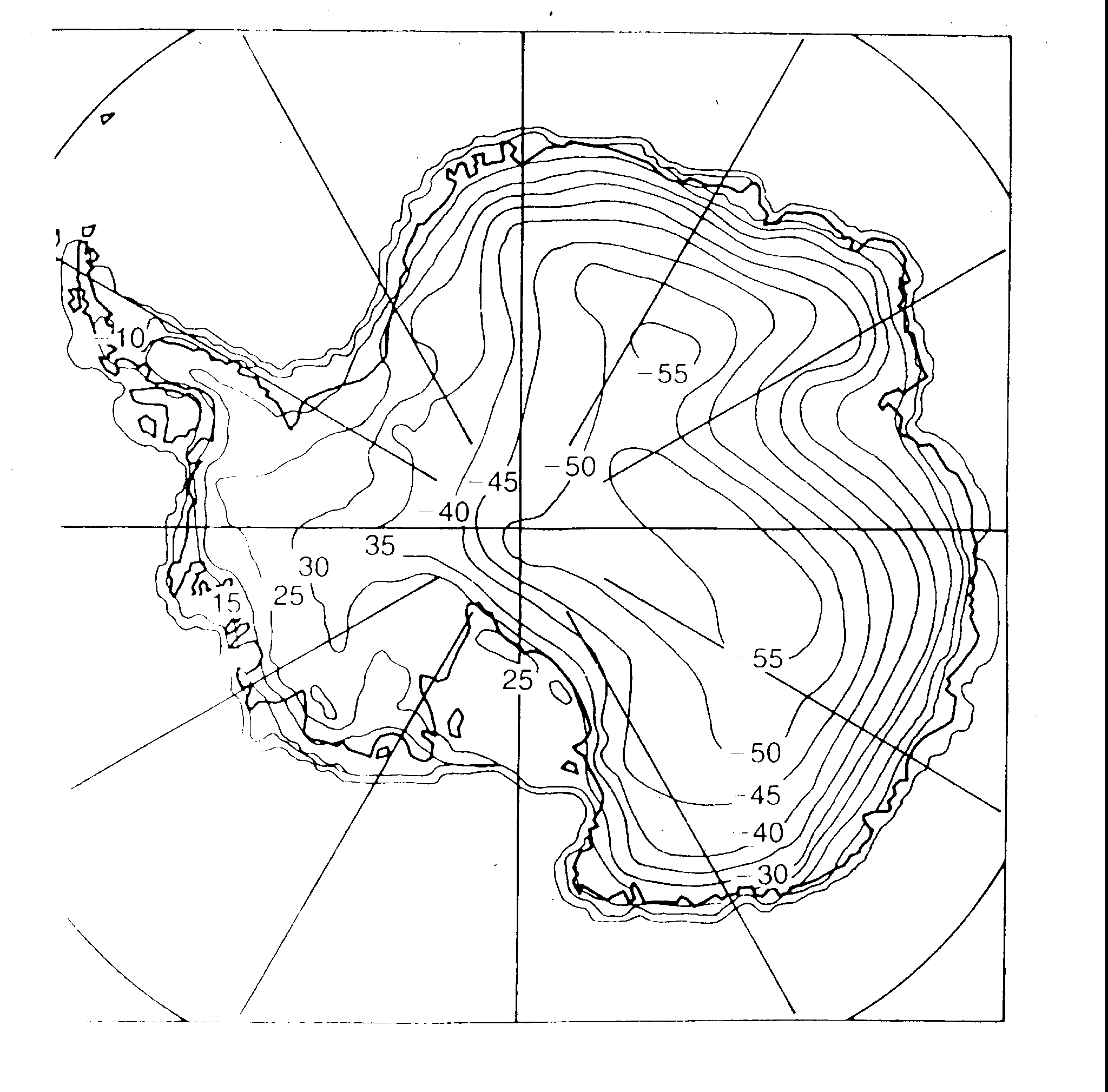
Fig 2. Annual mean surface temperature (° C) in Antarctica, inferred from measurements at 10 m depth in the snow, after Connolley & Cattle 1994, and Radok et al. 1987 (1).
There is considerable variation of temperatures from year to year. The standard deviation of annual mean temperatures is typically 0.61 - 1.56 K, more than the 0.5 K for London and the 0.6 K for Sydney, for instance. Seven places around Antarctica have shown a warming trend of 0.14 - 0.05 K/annum, whereas at the South Pole there has been no appreciable change since the 1970’s (-0.01 K/a). The average warming at 15 coastal stations around Antarctica during 1959-88 was 0.028 K/a, i.e. about three times the global average (2). At the same time, there was no discernible warming in the Arctic.
The Antarctic warming coincided with a reduction in the amount of solar radiation reaching sea level in the Arctic. The decline, 0.28 W/m2 per year between 1959-1988, is the average of pyranometer data at twelve stations in Antarctica, ten of which are coastal. The reason for this decline is not clear. There was no increase of cloud, nor a decrease of sea ice. Aerosol concentrations may have increased, as haziness has increased at several stations (2). This may have lead to a reduction in solar radiation, but also a larger reduction in longwave radiation loss, resulting in the observed warming.
There is some correlation between annual variations of temperature at the South Pole and the Southern Oscillation Index in the previous year (Fig. 3). A cold year followed a minimum SOI (i.e. an ENSO cold phase or El Niño), during 1955-85. This implies a remarkably far-reaching influence of an equatorial ENSO event on polar circulations of the atmosphere.
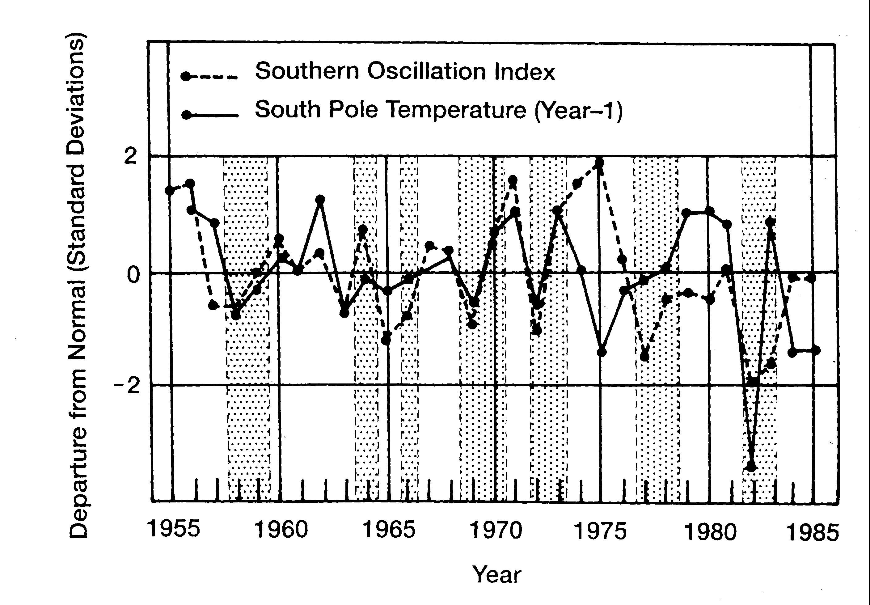
Fig. 3. The correlation of Southern Oscillation Index and the South Pole annual mean temperature in the following year, during 19956-1985, after Savage et al. 1988 (1).
The annual range of monthly mean temperatures depends on location. At the Faraday station, at 63° S on the Peninsula coast, it is only 11 K, but it is larger inland. A diurnal oscillation of temperatures is virtually absent, except along the coast, because of the high latitude and snow cover.
The clear skies and dry air above the Plateau allow continuous long-wave heat loss from the surface, and even during the summer little heating occurs because of the high surface albedo. The resulting equilibrium temperature profile is very stable: this is consistent with a downward sensible heat flux, which compensates the net radiational loss at the surface. For example, measurements at Vostok on the Plateau in July 1989 showed - 78° C at the surface, - 44° C about 600 m above (i.e. an inversion of 34 K !), and then cooling to -73° C at about 8,000 m (1). The inversion elsewhere in Antarctica in winter ranges from about 25 K inland to about 10 K around the coast, but its strength varies from-day-to-day, especially along the coast, as weather systems move and evolve.
Clouds are more common near the coast (in fact some coastal stations are overcast most of the time) and they are always stratiform (3).
References