Parallax correction in satellite images
If a satellite is far from the local zenith, or the satellite's viewing angle from nadir is large, clouds are displaced somewhat relative to the surface (Fig 1). This displacement, known as parallax, is more significant at places in the perimeter of the hemisphere viewed by a geostationary satellite, compared to those in the centre (Fig 2).
|

Fig 1. Illustration of the parallax displacement. High clouds are displaced further than low clouds. The illustration comparing high to low clouds assumes that the satellite is 52° from the local zenith (Fig 2). In examining the above schematic it should be noted that geostationary satellites orbit at 35,800 km above the Earth surface, whereas high clouds are at most 18 km above sea level. |
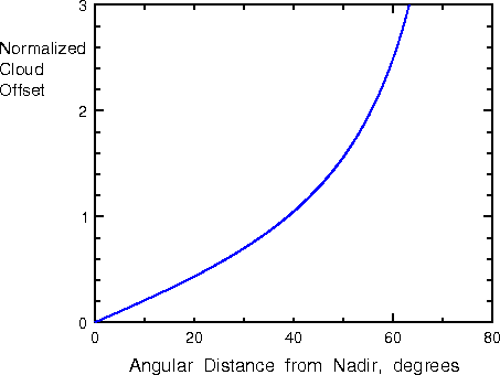
Fig 2. Normalized cloud offset for a geostationary satellite image, due to parallax induced cloud displacements. For a cloud at, say, 10 km altitude, at 60° latitude (and the same longitude as the satellite), the offset is just the height of the cloud multiplied by the normalized offset value from the graph, i.e. 10x2.6= 26 km. The direction of the apparent offset, of course, is directly away from the satellite, along a great circle arc from the subsatellite point. (source: (1)) |
Parallax displacement is important for high clouds such as cumulonimbus anvils (Fig 3).
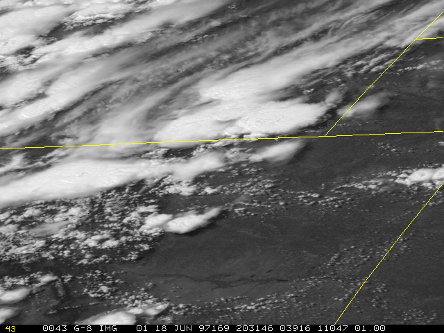
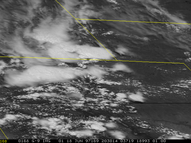
Fig 3. Two nearly simultaneous (1.5 minutes apart) satellite infrared images on 18 June 1997, from GOES 8 (top) and GOES 9 (bottom). Look at the cumulonimbus anvil in the southeastern corner of Wyoming (this is the state in the upper left quadrant of the images). GOES 9, looking at this storm from the southwest, misplaces the eastern edge of the anvil across the border into Nebraska. GOES 8, looking from the southeast, leaves the anvil well in Wyoming. Both satellites misplace the southern edge of the anvil north of the border with Colorado. In reality, the anvil spread a little into Colorado.
Reference
(1) Johnson, D. B., P. Flament and R.L. Bernstein, 1994. High-resolution satellite imagery for mesoscale meteorological studies. Bull. Amer. Meteor. Soc., 75, 5-33.