Changes in the size of the Antarctic ozone hole
|
E. Linacre |
11/'97 |
|
|
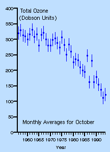
Since the mid-seventies until the mid-nineties, the Halley Bay ozone values indicated a steady fall of the October average (Fig 1). In the eighties this fall was confirmed by several other stations around Antarctica. The realisation in 1986 of the ozone hole’s existence led to a re-examination of TOMS data recorded earlier by the Nimbus satelite. These data had originally been dismissed because of unusually low ozone concentrations. It became evident that these satellite data had been showing the hole, unnoticed. This led to the discovery of the ‘Antarctic ozone hole’.
Fig 1 (left): Total ozone concentrations over Halley Bay, Antarctica. Both the mean and the variation are shown, the latter as an error bar whose length equals two standard deviations (source: British Antarctic Survey). |
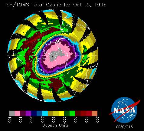
The Antarctic ozone hole can be defined as the region enclosed by the 220 DU (Dobson units, defined in Fig 1.5 in the book)). The area of this region (shown in Fig 1.5(b)) continued to increase slightly in 1996 (white line in Fig 2), starting earlier in the year and lasting later than previously. It can be seen that the size of the hole normally peaks in the end of September, when the Sun rises at the South Pole, and that the hole disappears in November.
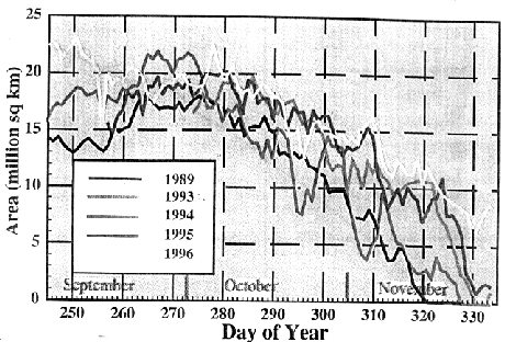
Fig 2: The daily area of the Antarctic ozone hole (defined as the 220 DU contour), in millions of square kilometres, at different times of five years (1).
A nice review of the Antarctic ozone hole is given by Jonathan Shanklin of the British Antarctic Survey.
Reference
(1) Halpert, M.S. and G.D. Bell, 1997: Climate assessment for 1996. Bull. Amer. Meteor. Soc., 78, 1-49.