Errata in the CD-ROM
Chapter 1
Multiple choice question 1.1: the correct answer should be a and b; 1.7: the correct answer should be a.
(add as an exercise in Chap 1) The pressure inside a plane is commonly maintained at about 850 hPa and 20° C, say, whilst the air scooped in for ventilation at 300 hPa is at -40° C and 300 hPa. Is it necessary to heat or to cool the air as it enters the cabin?
Chapter 11
Multiple choice question 11.2: the correct answers are: a and d.
Chapter 12
Note 12.F: the hyperlink for Fig 12.F.2 is wrong (it links to Fig 12.K.1).
Note 12.F: Fig 12.F.2 has caption belonging to Fig 12.F.1. The caption to Fig 12.F.2 should read: The effect of veering winds on thermal advection. The thick lines are the 300 hPa height contours (m). The thinner concentric lines are the 1000 hPa height contours (m). For a point labeled a, the low-level (Vl) and upper-level (Vu) geostrophic winds are shown, as well as the resulting 1000-300 hPa thermal wind (Vt). The layer-mean isotherms are parallel to the thermal wind. The direction of the temperature gradient over point a is indicated by "warm" and "cold".
Note 12.K: Fig 12.K.1 has caption belonging to Fig 12.K.2, and Fig 12.K.2 has caption belonging to Fig 12.K.3. What is missing, then, is a caption to Fig 12.K.1. Here it is. Relative vorticity can be decomposed in two parts: (a) curvature vorticity; (b) shear vorticity. The intuitively obvious rotation of the paddlewheel even in (b) shows that straight flow may contain vorticity.
Note 12.K: the caption of Fig 12.K.3 would be better if it read: The conservation of potential vorticity. When horizontal convergence occurs in the compressed vortex tube on the left, it will stretch, as shown on the right, and the relative vorticity will increase (just as the ice skater would spin faster), but the potential vorticity remains the same. The same applies for divergence, which causes a decrease in relative vorticity.
Chapter 13
Note 13.B
|
|
(the underlined should be added) (title) Note 13. B Frontal disturbances and baroclinic instability (third sentence) The combination of swerve and steep temperature gradient is unstable, and this instability is known as baroclinic instability. The term ‘baroclinic’ refers to the presence of a horizontal temperature gradient, and thermal advection as a result of wind blowing across the isotherms. Baroclinic instability leads to the growth of the original disturbance into a substantial low at ground level (i.e. ‘cyclogenesis’) and later to its decay. |
Exercise 13.1: wrong hyperlink: the link to Fig F13.2a should be to Fig F13.2a, which is on p 53.
Exercise 13.2: Fig F13.2.b has no caption. It should read: Analysed chart of Southeast Australia, at 3pm on 23/8/'91.
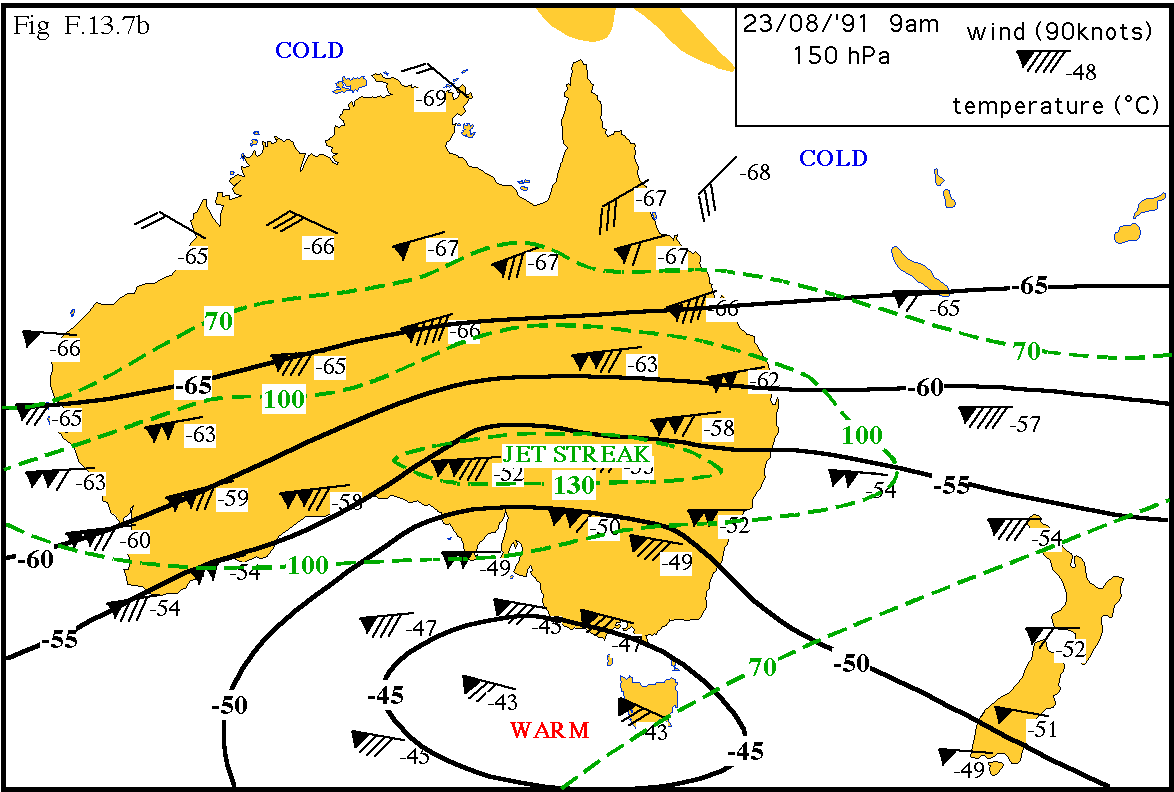
Exercise 13.7: Fig F13.7.b has the right caption, but the graphic is wrong: the graphic shown is actually Fig 13.B.1. Fig F13.7.b is shown here.
Photo Gallery
The highlighted words "Morning glory" should link to Fig I.8.4 (currently it links to Fig I.8.3)
The authors would appreciate the communication of any error in the book or CD.