Sea breezes and thunderstorms
|
B. Geerts |
1/’02 |
![]()
|
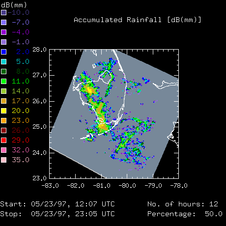
When the atmosphere is conditionally unstable, the forced ascent of PBL air over a sea breeze front may trigger deep convection. As such the inland propagation of the sea breeze front may control when and where thunderstorms occur in a coastal region. This control of the sea breeze circulation on deep convection is only possible when synoptic-scale forcing is negligible, i.e. in tropical regions and at higher latitudes during the summer. On 'mesoscale' peninsulas (20-200 km wide) sea breezes from opposite coasts may collide, and in the absence of large-scale wind (or gradient wind, Note 14.C), two lines of thunderstorms may converge towards the axis of the peninsula, where they combine into a single vigorous but short-lived line. An example of a narrow peninsula is the northern tip of New Zealand, from Auckland northward (1). A northeasterly gradient wind usually prevails, resulting in single, quasi-stationary line of convection along the western coast. The Florida peninsula is about 3 times wider, therefore opposing sea breezes usually don’t penetrate far enough to meet (Fig 1). Further inland the sea breeze front is often deformed or destroyed by cool outflow from thunderstorms. Therefore inland thunderstorms are often triggered by converging or collapsing outflow boundaries (1,2). |
Fig 1. Radar-estimated rainfall during 12 hours in Southern Florida. The prevailing ('gradient wind') flow was from the east on this day. Therefore the convergence (and ensuing convection) was strongest along the west coast. The east coast sea breeze penetrated further inland but did not produce much deep convection, except near Lake Okeechobee, due to convergence with the lake breeze near the Lake's eastern shore. The east coast and west coast sea breezes appear to have collided in southern Florida but further north (around Lake Okeechobee). |
When the atmosphere is conditionally unstable, the forced ascent of PBL air over a sea breeze front may trigger deep convection. As such the inland propagation of the sea breeze front may control when and where thunderstorms occur in a coastal region. This control of the sea breeze circulation on deep convection is only possible when synoptic-scale forcing is negligible, i.e. in tropical regions and at higher latitudes during the summer.
On 'mesoscale' peninsulas (20-200 km wide) sea breezes from opposite coasts may collide, and in the absence of large-scale wind (or gradient wind, Note 14.C), two lines of thunderstorms may converge towards the axis of the peninsula, where they combine into a single vigorous but short-lived line. An example of a narrow peninsula is the northern tip of New Zealand, from Auckland northward (3). A northeasterly gradient wind usually prevails, resulting in single, quasi-stationary line of convection along the western coast.
The Florida peninsula is much wider, therefore opposing sea breezes usually don’t penetrate far enough to meet. Further inland the sea breeze front is often deformed or destroyed by cool outflow from thunderstorms. Therefore inland thunderstorms are often triggered by converging or collapsing outflow boundaries.
One could argue that a knowledge of the gradient wind and of the details of the terrain (topography, coastline and lakes, variations of land albedo and wetness) would yield excellent weather forecasts in Florida and other areas under a sea breeze regime. This argument is valid as long as the air is dry or stable enough to inhibit thunderstorms. For instance, the arrival, intensity and inland penetration of the Perth Doctor can be accurately simulated. In Florida, where the atmosphere is conditionally unstable almost every day in summer, it is true that initial and surface conditions are fairly well known. And with these conditions the details of the sea breeze circulation can be simulated most accurately with even simple NWP models. However once deep convection breaks out, the PBL flow patterns become much more complex, and the simulation of cloud microphysical and turbulent transports is most challenging.
Thunderstorms act as a negative feedback to the sea breeze circulation, because they cool the inland PBL. Therefore sea breezes are typically stronger in dry, stable conditions, as in South Australia, southwestern Australia, and Namibia. An additional factor enhances sea breeze strength (and penetration depth) in these desert regions is the large coastal temperature gradient. Off Namibia, for instance, the Benguela Current and coastal upwelling lead to low sea-surface temperatures.
Reference
(1) Kingsmill, D.E., 1995. Convection initiation associated with a sea breeze front, a gust front, and their collision. Mon. Wea. Rev., 123, 2913-33.
(2) Fankhauser, J.C., N. A. Crook, J. Tuttle, L.J. Miller and C.G. Wade, 1995. Initiation of deep convection along boundary layer convergence lines in a semitropical environment. Mon. Wea. Rev., 123, 291-313.
(3) Sturman, A. and N. Tapper 1996. The Weather and Climate of Australia and New Zealand. (Oxford Univ. Press) 476pp.