Tropical cyclogenesis
|
B. Geerts |
3/’02 |
![]()
How do tropical cyclones form and
intensify ?
Early stages in the development of a tropical cyclone demonstrate nicely the way in which positive feedback causes growth. These steps follow one another -
- A cluster of thunderstorms (in or near the ITCZ, over warm water) heats the middle and upper troposphere, by latent heat release. This heating only occurs when the air parcel, rising from the surface, is warmer than the environment, in other words when it is buoyant. And this only happens when the environmental lapse rate at some levels exceeds the moist adiabatic lapse rate, i.e. when the atmosphere is conditionally unstable.
- This heating explains the development of a weak surface low, by hydrostatic balance (Note 1.G).
- This centre of low pressure at sea level triggers winds, which converge into the low and, if the cluster is at least 5° of latitude from the equator, the winds are deflected by the Coriolis force sufficiently to cause cyclonic rotation.
- The surface winds promote evaporation and heat transfer from the ocean surface into the marine boundary layer. This link is essential. Normal thunderstorms are short-lived, because thunderstorms cool the boundary-layer air. According to Dalton's equation (Note 4.E), the evaporation rate is linearly proportional to the wind speed. It may be even more sensitive, because strong winds produce ocean spray, much of which evaporates (1).
- The convergence of wind, plus the increased water vapour content, produces moisture convergence over the low.
- This convergence fuels the cloud cluster, so that more rain falls, and more latent heat is released in the troposphere (stage 1). This heating deepens the surface low (stage 2). Consequently stages 3 - 6 are repeated on a larger scale, over and over again. A tropical depression is born, which may further intensify into a tropical cyclone. The stronger the surface winds, the more effective the heat transfer from the ocean.
This feedback loop does not work over cold waters: only over warm waters (at least 27°C) is the saturation vapour pressure high enough to provide enough latent heat. It does not work over land, because the latent heat feedback does not work (stronger winds do not imply more evaporation), instead, there is a negative feedback: stronger winds imply frictional retardation. And even when all conditions are right (a warm oceans with a conditionally unstable, weakly sheared troposphere), tropical cyclones are relatively rare: most cloud clusters do not develop into tropical storms, and most tropical storms do not grow into tropical cyclones (or hurricanes). There is another negative feedback: convective motion stabilizes the atmosphere, and only a continued influx of warm, moist air at low levels can sustain the convection. Moreover, tropical cyclones extract a lot of heat from the ocean, and some slow-moving cyclones have dissipated because the heat transfer and wind-driven upwelling lowered the SST below 27°C.
What limits the intensity of tropical
cyclones ?
|
In essence, the surface winds enhance the heat transfer from the ocean such that the boundary layer air feeding into the storm cluster always has an equivalent potential temperature that is higher than that in the middle troposphere. The equivalent potential temperature is a measure of the energy content of the air. If you assume that a tropical cyclone is a closed circulation with inflow at low levels, uplift in the wall cloud, difluence aloft and subsidence in the surroundings (Fig 1), then it is easy to think of a tropical cyclone as a Carnot engine (2). Heat energy is added on the warm side (leg 1). This heating offsets the cooling due to expansion as the air moves towards the centre of the low. The energy generated in the cycle is consumed by friction, mainly along the sea surface. Ultimately it is friction that limits hurricane intensity: with increasing wind speed, mechanical dissipation grows with the cube of the wind speed, i.e. faster than the ocean heat transfer. The thermodynamic efficiency of this cycle (e ) is calculated simply as e = (Tw - Tc)/Tw. So the warmer the sea-surface (Tw) and the colder the tropopause (Tc), the more efficient the tropical cyclone will be. Assuming a typical SST of 300 K and a tropopause temperature of 200 K, you find that the typical tropical storm efficiency is 1/3. By taking into account both the efficiency and the rate of heat transfer from the ocean, Emanuel (2) contrived an upper intensity limit for tropical cyclones, which depends mostly on sea surface and tropopause temperatures. This upper limit corresponds well with the intensity of observed extreme storms (Fig 2). |
Fig 1. The net circulation of air in a cross section through a tropical cyclone. The eye is along the left border and the eyewall is shown as the main cloud just to the right. In leg 2, for instance, air is carried up in the eyewall, and just below the tropopause it diverges from the eye. Leg 1 is isothermal. Legs 2 and 4 are adiabatic (moist expansion and dry compression respectively) and Leg 3 is isothermal as compressional heating is balanced by radiational heat loss into space. |
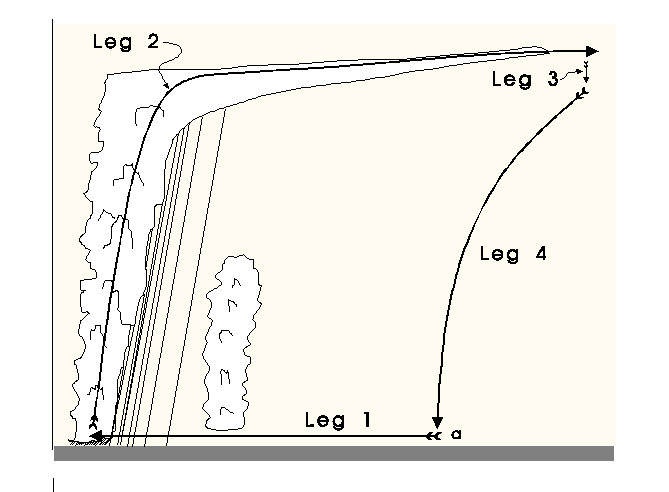
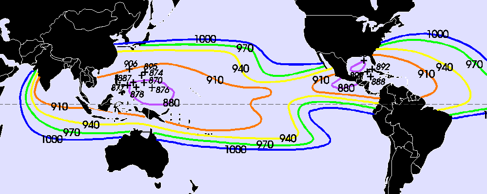
Fig 2. The maximum intensity (i.e. lowest central pressure, in hPa) of tropical cyclones in August (when they are most common in the northern hemisphere), according to Emanuel's theory (2). Also plotted are the positions and central pressures of some of the most intense tropical storms ever observed.
Hypercanes
In numerical simulations with just slight variations in the range of today's sea surface and tropopause temperatures, Emanuel (2) found 'runaway' hurricanes with central pressures at sea level as low as 200 hPa. This explosive growth is only possible when some threshold SST is reached over a large ocean area, e.g. 34°C. This may not seem like a large aberration from current SSTs. However, the tropical ocean acts like a thermostat, and the atmosphere would need to change significantly for the SST to exceed say 30°C.
Emanuel proposes that these 'super-hurricanes' (known as hypercanes) may have caused the extinction of dinosaur at the end of the Cretaceous era, 60 million years ago. Oxygen isotope ratios in ocean sediments, as well as other evidence, show that this was a warm period. Seawater could be heated further locally, by either a direct hit from a meteor, or underwater volcanic activity. One or more hypercanes could have formed. Because of their massive updraft strength and size, hypercanes would deposit large amounts of ice crystals and aerosols, including sea salt from evaporated sea spray, into the lower stratosphere. This would lower surface temperatures (in the same way as large volcanic eruptions cause surface cooling), and this could lead to a cold period lasting several years, long enough to kill all plant life on which dinosaurs subsisted.
References
- Holland, G., 1997. The maximum potential intensity of tropical cyclones. J. Atmos. Sci., 54, 2519-2541
- Emanuel, K. A., 1986. An air-sea interaction theory for tropical cyclones. Part I. J. Atmos. Sci., 42, 1062-1071.