Precipitation and orography
|
B. Geerts |
3/’02 |
![]()
Examples
Mountains dramatically alter geographical precipitation patterns. The Hawai'ian Islands offers a nice example. Though they lie around 20° N under a prevailing subtropical high in a region that receives only about 700 mm/a (1), tall mountains on the islands trigger substantial orographic rainfall from the moist Trade winds. The annual rainfall on Mt Waialeale on the island of Kauai has exceeded 10,000 mm on occasion. On the other hand, only 510 mm/a falls on Honolulu, which lies in the rain shadow of a mountain. In the Western United States, with a series of mountain ranges aligned north-to-south, most of the precipitation is captured by the mountains along the coast, with decreasing amounts over mountain ranges further inland, even though the inland ranges are generally higher in elevation than the coastal ranges.
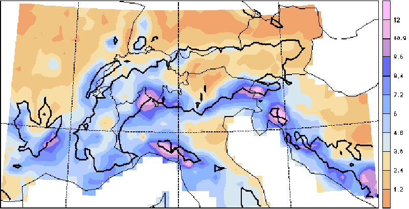
Another example comes from the European Alps (Fig 1). Heavy rainfall is most common on the western and southern flanks of the mountains. In October the prevailing rain-bearing winds are from 180 to 270° , and the precipitation is largely stratiform. Note the difference between the French (upstream) and Austrian (downstream) Alps.

Fig 1. Climatological frequency of heavy precipitation (over 20 mm/day) over the Alps during the month of October. Color coding shows percentage of days. The bold line is the 1000 m contour line (from (1)).
These local variations cannot be estimated accurately by satellite-based methods, and even ground-based weather radars generally underestimate the amount of orographic precipitation. Only a dense network of raingauges can accurately assess rainfall amounts in complex terrain.
Mechanisms
|
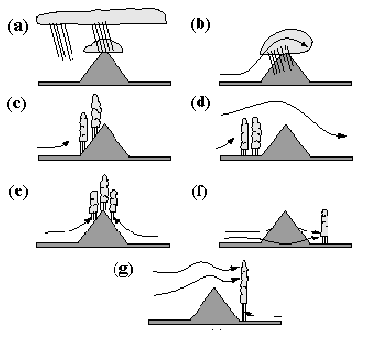
There are several mechanisms of orographic precipitation (Fig 2). (a) Seeder-Feeder mechanism: ice crystals fall from a glaciated stratiform cloud aloft onto an orographically-generated cloud of supercooled droplets. The ice crystals glaciate this cloud (Bergeron-Findeisen process, Section 9.2). The resulting snowfall is light, unless uplift sustains condensation in the lower cloud (second process). (b) Stably stratified air can be forced to raise over a mountain ridge. The rising air cools, becomes saturated, and cloud and precipitation results. The rainrate can be estimated from upstream radiosonde data, i.e. the temperature, dewpoint and wind profiles. This is the most common type of orographic rainfall, especially in mid-latitudes. In Hawai'i the sustained uplift of marine boundary layer air over the mountains, but below the freezing level, results in steady rain, formed by warm rain processes (condensation and coalescence). (c) Deep convection can break out in potentially unstable air as it is lifted over a mountain ridge. Potential instability implies that the equivalent potential temperature in the PBL is higher than that above the PBL. Thunderstorms are found between the foothills and the mountain crest, although anvils or convectively-triggered upper-level stratiform precipitation areas may drift to the lee side of the mountains. (d) Deep convection can also be triggered further upstream, possibly along a surface boundary (in temperature, dewpoint, and/or wind) that developed because of the mountains. |
Fig 2: Mechanisms of orographic precipitation: (a) Seeder-Feeder mechanism; (b) upslope condensation; (c) upslope triggering of convection; (d) upstream triggering of convection; (e) thermal triggering of convection; (f) leeside triggering of convection; (g) leeside enhancement of convection. Slanted lines below cloud base indicate precipitation. [From Fig. 12.24 of Houze, 1993]. |
(e) In the absence of significant large-scale wind, especially at low levels, topographically-induced boundary-layer flows develop due to daytime heating and nighttime cooling differences, and convergence of these flows may trigger thunderstorms in a conditionally unstable airmass. This is the leading mechanism of orographic rainfall enhancement near the ITCZ, such as Indonesia (Note 16.J), and it also plays a role at higher latitudes during the warm season.
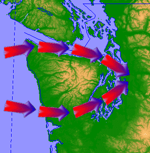
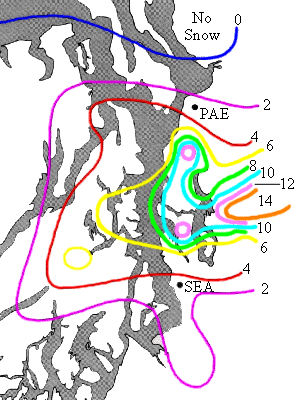
(f) Stable air may be forced around an isolated mountain, rather than over it. In this case the leeside convergence of air may result in uplift and enhanced rainfall, possibly convective rainfall. An example is the Puget Sound Convergence Zone near Seattle, USA (Fig 3 and Fig 4).
|
|
Fig 3 (left): Schematic pattern of low-level airflow around the Olympic Mountains in the northwestern corner of the contiguous USA. The inland waters are called the Puget Sound, hence the 'Puget Sound Convergence Zone'.
Fig 4 (right): 24h snowfall accumulations in the vicinity of the Puget Sound, in inches, on December 18, 1990. Larger snowfall amounts were recorded further east, over the Cascade Mountains, but the effect of the Puget Sound Convergence Zone can be clearly seen. SAE= Seattle Tacoma International Airport; PAE = Paine Airport, Everett. |
|
(g) Deep, and often severe convection may be triggered in the lee of a mountain range as a warm, juicy airmass at low levels, in the lee, finds itself below much cooler air aloft, originating from across the mountains. The colder, drier air aloft may not be able to replace the warm air near the surface because the latter is often capped by a thin, stable layer. This leads to extremely unstable conditions, and the concomitant wind shear is responsible for the occasionally tornadic storm intensity. This scenario is common east of the Rocky Mountains of North America, especially in late spring/early summer.
(h) (not shown in Fig 2) Leeside enhancement of precipitation is also possible when stably-stratified flow crosses a mountain ridge. One or more lee-waves may form in the middle to upper troposphere, and ice crystals may fall from the orographic clouds to enhance precipitation from a more shallow, stratiform cloud some 20-50 km downstream of the ridge, through the Seeder-Feeder mechanism. This mechanism is important in Arizona, for instance (3).
References
(1) Frei, C., and C. Schär, 1998. A precipitation climatology of the Alps from high-resolution rain-gauge observations. Int. J. Climatol., 18, in press.
(2) Houze, R. A. Jr., 1993. Orographic Clouds, in Cloud Dynamics, Academic Press, 502-538.
(3) Klimowski, B.A., R. Becker, E.A. Betterton, R. Bruintjes, T.L. Clark, W.D. Hall, B.W. Orr, R.A. Kropfli, P. Piironen, R. Reinking, D. Sundie, and T. Uttal, 1998. The 1995 Arizona Program: toward a better understanding of winter storm precipitation development in mountainous terrain. Bull. Amer. Meteor. Soc., 79, 799-813.


