|
E. Linacre and B. Geerts |
1/'99 |
Description
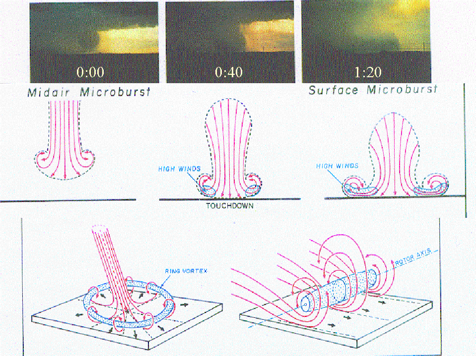
Microbursts are strong winds concentrated in an area less than 4 km in diameter, beneath a convective downdraft, usually associated with a cumulonimbus cloud. The column then ‘splashes’ onto the ground (Fig 1), creating winds outwards of up to 70 m/s. Microbursts are either dry (i.e. little or no rain reaches the ground) or wet (usually within a downpour). The radial pattern means winds of various directions within a small area, and hence considerable wind shear near the ground, for up to ten minutes.
Fig 1. The top three images show a wet microburst touching down and spreading. The interval between the images is just 40 seconds. The three schematics below show the airflow and the regions of high wind around the time of touchdown. The two schematics at the bottom illustrate the ring vortex, with a horizontal 'rotor' axis around the microburst. This vortex spreads and therefore (temporarily) intensifies after touchdown. (1)
Aviation hazard
This wind shear can cause havoc to aircraft in the vicinity of the runway. A few aircraft accidents have been attributed to microbursts. For instance, Panam flight 759 in New Orleans on 9 July 1982 crashed shortly after take-off because of a microburst at the end of the runway (Fig 2). Accidents are the result of a sudden change from headwind to tailwind. This reduces the lift of the aircraft, which may force the aircraft down, either during take-off or landing. The downdraft itself and the increased drag and weight of heavy rain are less important factors.
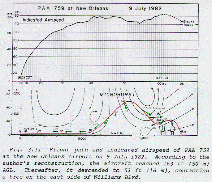
Fig 2. Flight trajectory (red line), winds (green arrows), and indicated airspeed of PAA 759 (1).
Mechanisms
Reference
(1) Fujita, T.T., 1985. Downburst: microburst and macroburst. Report of Projects NIMROD and JAWS. Satellite and Mesometeorology Research Project paper #210, Univ. of Chicago, Chicago, IL, 122 pp.